- Hjem
- Forbrukerelektronikk
- Bil
- Navigasjon
- Navigatorkart
- Garmin VAE006R - Timor Leste/New Guinea, microSD/SD – 010-C0881-00
Garmin VAE006R - Timor Leste/New Guinea, microSD/SD


Garmin VAE006R - Timor Leste/New Guinea, microSD/SD
MPN 010-C0881-00
Varenr. W125648012
EAN/UPC 0753759070618
Lagernivå
See your vessel’s precise, on-chart position in relation to navaids, coastal features and restricted areas with premium features found in this detailed marine mapping data. Includes all of the features of our BlueChart® g2 product, plus 3-D perspective above and below the waterline, Auto Guidance, high-resolution imagery, and aerial photos of ports, harbors, marinas and landmarks.
- Shaded depth contours, coastlines, spot soundings, navaids, port plans, wrecks, obstructions, intertidal ...
Spesifikasjoner for 010-C0881-00
Features
Geographic coverage
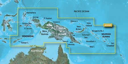
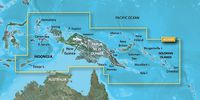
Timor Leste/New Guinea
Type
Road map
Package dimensions
Depth (package,cm)
13,018 cm
Gross Weight (Package, kg)
0,02 kg
Height (package,cm)
0,953 cm
Width (package,cm)
12,065 cm
Product dimensions
Net Weight (Product, kg)
0,01 kg
Product Depth
0,2 cm
Product Height
3,2 cm
Product Width
2,4 cm
Vendor information
Brand Name
Warranty
2 År
Beskrivelse
VAE006R - Timor Leste/New Guinea, microSD/SD
See your vessel’s precise, on-chart position in relation to navaids, coastal features and restricted areas with premium features found in this detailed marine mapping data. Includes all of the features of our BlueChart® g2 product, plus 3-D perspective above and below the waterline, Auto Guidance, high-resolution imagery, and aerial photos of ports, harbors, marinas and landmarks.
- Shaded depth contours, coastlines, spot soundings, navaids, port plans, wrecks, obstructions, intertidal zones, restricted areas and IALA symbols.
- Seamless transitions between zoom levels and more continuity across chart boundaries.
- High resolution satellite imagery for a realistic view of the land and water.
- Aerial photos of ports, harbors, marinas, waterways, navigational landmarks and other POIs.
- Auto Guidance technology searches chart data to suggest the best passage to a destination.
- MarinerEye view 3-D perspective for a quick, easy position fix.
- FishEye view 3-D perspective for an underwater view of the sea floor.
- Safety Shading* enables contour shading for all depth contours shallower than your defined safe depths.
- Fishing Charts* to scope out bottom contours and depth soundings with less visual clutter on the display.
- Plan and organize routes from your computer with HomePort™ (sold separately).
Coverage
General coverage includes coasts of Timor Leste; the northernmost parts of Melville Island and the Cobourg Peninsula of Australia; Indonesia southeast and east of Sulawesi; Osprey Reef; all of Papua New Guinea and the Solomon Islands. Detailed coverage of Ambon, Indonesia; Snake Bay, Australia; Ternate, Indon, Lae, Rabaul, Karema and Port Moresby, P.N.G. and Honaira, S.I.
*Produktinformasjonen ovenfor er levert av Icecat. EET kan ikke holdes ansvarlig for feil i forbindelse med dette.