- Hjem
- Forbrukerelektronikk
- Bil
- Navigasjon
- Navigatorkart
- Garmin HEU001R - English Channel, microSD/SD – 010-C0760-20
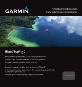
Garmin HEU001R - English Channel, microSD/SD


Garmin HEU001R - English Channel, microSD/SD
MPN 010-C0760-20
Varenr. W125647959
EAN/UPC 0753759091446
Lagernivå
See your vessel’s precise, on-chart position in relation to navaids, coastal features, anchorages, obstructions, waterways, restricted areas and more with this detailed marine mapping data.
- Shaded depth contours, coastlines, spot soundings, navaids, port plans, wrecks, obstructions, intertidal zones, restricted areas and IALA symbols.
- Seamless transitions between zoom levels and more continuity across chart boundaries.
- Standard 2-D direct overhead or 3-D “over the bow” map...
Spesifikasjoner for 010-C0760-20
Features
Geographic coverage
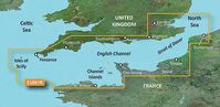
English Channel
Type
Road map
Package dimensions
Depth (package,cm)
13,018 cm
Gross Weight (Package, kg)
0,02 kg
Height (package,cm)
0,953 cm
Width (package,cm)
12,065 cm
Product dimensions
Net Weight (Product, kg)
0,01 kg
Product Depth
0,2 cm
Product Height
3,2 cm
Product Width
2,4 cm
Vendor information
Brand Name
Warranty
2 År
Beskrivelse
HEU001R - English Channel, microSD/SD
See your vessel’s precise, on-chart position in relation to navaids, coastal features, anchorages, obstructions, waterways, restricted areas and more with this detailed marine mapping data.
- Shaded depth contours, coastlines, spot soundings, navaids, port plans, wrecks, obstructions, intertidal zones, restricted areas and IALA symbols.
- Seamless transitions between zoom levels and more continuity across chart boundaries.
- Standard 2-D direct overhead or 3-D “over the bow” map perspective for easy chart reading and orientation.
- Safety Shading* enables contour shading for all depth contours shallower than your defined safe depths.
- Fishing Charts* to scope out bottom contours and depth soundings with less visual clutter on the display.
- Plan and organize routes from your computer with HomePort™.
Coverage
British coast: covers from Felixstowe to the Isles of Scilly, including Dover, The Solent, and the Isle of Wight. Also covers the River Thames from Twickenham to the North Sea. French coast: covers from Dunkerque to L'Aber Wrac'h, including Rouen and the Channel Islands
*Produktinformasjonen ovenfor er levert av Icecat. EET kan ikke holdes ansvarlig for feil i forbindelse med dette.