- Sākums
- Elektronika
- Automobiļi
- Navigācija
- Navigator Maps
- Garmin VUS010R - Southeast Florida, microSD/SD – 010-C0711-00
Garmin VUS010R - Southeast Florida, microSD/SD


Garmin VUS010R - Southeast Florida, microSD/SD
MPN 010-C0711-00
EAN / UPC 753759068912
Krājumi
See your vessel’s precise, on-chart position in relation to navaids, coastal features and restricted areas with premium features found in this detailed marine mapping data. Includes all of the features of our BlueChart® g2 product, plus 3-D perspective above and below the waterline, Auto Guidance, high-resolution imagery, and aerial photos of ports, harbors, marinas and landmarks.
- Shaded depth contours, coastlines, spot soundings, navaids, port plans, wrecks, obstructions, intertidal zo...
Specifikācijas 010-C0711-00
Features
Brand compatibility
Garmin
Coverage details
Southeast Florida
Distribution type
MicroSD/SD
Number of users
1 lietotājs(i)
Region location
North America
Type
Water map
Package dimensions
Gross Weight (Package, kg)
5 kg
Product dimensions
Net Weight (Product, kg)
4,9 kg
Product Depth
12,3 cm
Product Height
2 cm
Product Width
13 cm
System requirements
Internet connection required
Yes
Minimum display resolution requirement
1024 x 768 Pixels
Minimum RAM
1024 MB
Minimum storage drive space
0,951 GB
USB required
Yes
Vendor information
Brand Name
Warranty
2 Gads (-i)
Apraksts
VUS010R - Southeast Florida, microSD/SD
See your vessel’s precise, on-chart position in relation to navaids, coastal features and restricted areas with premium features found in this detailed marine mapping data. Includes all of the features of our BlueChart® g2 product, plus 3-D perspective above and below the waterline, Auto Guidance, high-resolution imagery, and aerial photos of ports, harbors, marinas and landmarks.
- Shaded depth contours, coastlines, spot soundings, navaids, port plans, wrecks, obstructions, intertidal zones, restricted areas and IALA symbols.
- Seamless transitions between zoom levels and more continuity across chart boundaries.
- High resolution satellite imagery for a realistic view of the land and water.
- Aerial photos of ports, harbors, marinas, waterways, navigational landmarks and other POIs.
- Auto Guidance technology searches chart data to suggest the best passage to a destination.
- MarinerEye view 3-D perspective for a quick, easy position fix.
- FishEye view 3-D perspective for an underwater view of the sea floor.
- Safety Shading* enables contour shading for all depth contours shallower than your defined safe depths.
- Fishing Charts* to scope out bottom contours and depth soundings with less visual clutter on the display.
- Plan and organize routes from your computer with HomePort™.
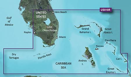
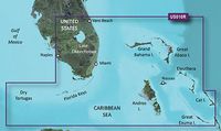
Coverage
FEATURING DATA FROM EXPLORER CHARTS FOR THE BAHAMAS!!! Vero Beach south to include Lake Okeechobee, Florida Keys, Dry Tortugas, and covering the west coast of Florida north to Naples. Also covered all the Bahamas, Andros Island, Eleuthera Island, Cat Island, Great Exuma Island, Little Exuma Island, and Hog Cay.
*Iepriekš minētos datus par produktu sniedz Icecat. EET nevar būt atbildīgs par kļūdām saistībā ar to.