- Kezdőlap
- Fogyasztói elektronika
- Autóipari
- Navigáció
- Navigátor térképek
- Garmin HPC019R - Polynesia, microSD/SD – 010-C0866-20
Garmin HPC019R - Polynesia, microSD/SD


Garmin HPC019R - Polynesia, microSD/SD
MPN 010-C0866-20
Cikkszám W125648009
EAN / UPC 0753759089825
Készlet szint
See your vessel’s precise, on-chart position in relation to navaids, coastal features, anchorages, obstructions, waterways, restricted areas and more with this detailed marine mapping data.
- Shaded depth contours, coastlines, spot soundings, navaids, port plans, wrecks, obstructions, intertidal zones, restricted areas and IALA symbols.
- Seamless transitions between zoom levels and more continuity across chart boundaries.
- Standard 2-D direct overhead or 3-D “over the bow” map...
Specifikációk a termékről 010-C0866-20
Features
Geographic coverage
Polynesia
Language version
Unspecified
Type
Road map
Package dimensions
Depth (package,cm)
13,018 cm
Gross Weight (Package, kg)
0,02 kg
Height (package,cm)
0,953 cm
Width (package,cm)
12,065 cm
Product dimensions
Net Weight (Product, kg)
0,01 kg
Product Depth
0,2 cm
Product Height
3,2 cm
Product Width
2,4 cm
Vendor information
Brand Name
Warranty
2 Év(ek)
Leírás
HPC019R - Polynesia, microSD/SD
See your vessel’s precise, on-chart position in relation to navaids, coastal features, anchorages, obstructions, waterways, restricted areas and more with this detailed marine mapping data.
- Shaded depth contours, coastlines, spot soundings, navaids, port plans, wrecks, obstructions, intertidal zones, restricted areas and IALA symbols.
- Seamless transitions between zoom levels and more continuity across chart boundaries.
- Standard 2-D direct overhead or 3-D “over the bow” map perspective for easy chart reading and orientation.
- Safety Shading* enables contour shading for all depth contours shallower than your defined safe depths.
- Fishing Charts* to scope out bottom contours and depth soundings with less visual clutter on the display.
- Plan and organize routes from your computer with HomePort™.
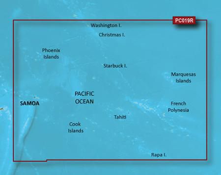
Coverage
General coverage of the coasts of Tonga, Samoa, American Samoa, French Polynesia, Kiribati, and the Cook Islands. Included in this overall general coverage are numerous detailed charts covering areas such as Nuku'alofa, Ton., Apia, Sam., Pago Pago, Am. Sam., Tahiti, and Bora Bora.
*A fenti termékadatokat az Icecat szolgáltatja. Az EET nem tehető felelőssé az ezzel kapcsolatos hibákért.