- Home
- Consumentenelektronica
- Automotive
- Navigatie
- Navigatie Mappen
- Garmin HAE005R - Philippines-Java-Mariana Islands, microSD/SD – 010-C0880-20
Garmin HAE005R - Philippines-Java-Mariana Islands, microSD/SD

Garmin HAE005R - Philippines-Java-Mariana Islands, microSD/SD
MPN 010-C0880-20
EAN/UPC 753759090081
Voorraadniveau
See your vessel’s precise, on-chart position in relation to navaids, coastal features, anchorages, obstructions, waterways, restricted areas and more with this detailed marine mapping data.
- Shaded depth contours, coastlines, spot soundings, navaids, port plans, wrecks, obstructions, intertidal zones, restricted areas and IALA symbols.
- Seamless transitions between zoom levels and more continuity across chart boundaries.
- Standard 2-D direct overhead or 3-D “over the bow” map per...
Specificaties voor 010-C0880-20
Features
Brand compatibility
Garmin
Coverage details
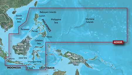
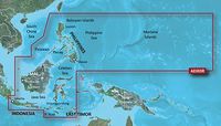
Philippines - Java-Mariana Islands
Distribution type
MicroSD/SD
Number of users
1 gebruiker(s)
Region location
Asia
Type
Water map
Package dimensions
Gross Weight (Package, kg)
35 kg
Product dimensions
Net Weight (Product, kg)
34,9 kg
Product Depth
12,3 cm
Product Height
2 cm
Product Width
13 cm
System requirements
Internet connection required
Yes
Minimum display resolution requirement
1024 x 768 Pixels
Minimum RAM
1024 MB
Minimum storage drive space
0,957 GB
USB required
Yes
Vendor information
Brand Name
Warranty
2 Ja(a)r(en)
Beschrijving
HAE005R - Philippines-Java-Mariana Islands, microSD/SD
See your vessel’s precise, on-chart position in relation to navaids, coastal features, anchorages, obstructions, waterways, restricted areas and more with this detailed marine mapping data.
- Shaded depth contours, coastlines, spot soundings, navaids, port plans, wrecks, obstructions, intertidal zones, restricted areas and IALA symbols.
- Seamless transitions between zoom levels and more continuity across chart boundaries.
- Standard 2-D direct overhead or 3-D “over the bow” map perspective for easy chart reading and orientation.
- Safety Shading* enables contour shading for all depth contours shallower than your defined safe depths.
- Fishing Charts* to scope out bottom contours and depth soundings with less visual clutter on the display.
- Plan and organize routes from your computer with HomePort™.
Coverage
General coverage of the coasts of the Philippines, portions of Indonesia, including Java, and Malaysia located to the east of Singapore and west of Halmahera Island, and portions of East Timor. Included in this overall general coverage are numerous detailed charts covering areas such as the Indonesian cities of Jakarta, Semarang, and Ujungpandang, Manila, Phil., Kota Kinabalu, Mal., and Bandar Seri Begawan, Brun. General coverage of the Mariana Islands is also included.
*Bovenstaande productgegevens zijn aangeleverd door Icecat. EET kan hiervoor niet aansprakelijk gehouden worden.