- Pagrindinis puslapis
- Laisvalaikio elektronika
- Automobilių įranga
- Navigacija
- Žemėlapių navigatoriai
- Garmin Sweden Inland Waters – 010-C1209-20
Garmin Sweden Inland Waters

Garmin Sweden Inland Waters
MPN 010-C1209-20
Prekės nr. W125648008
EAN/UPC 0753759255350
Atsargų lygis
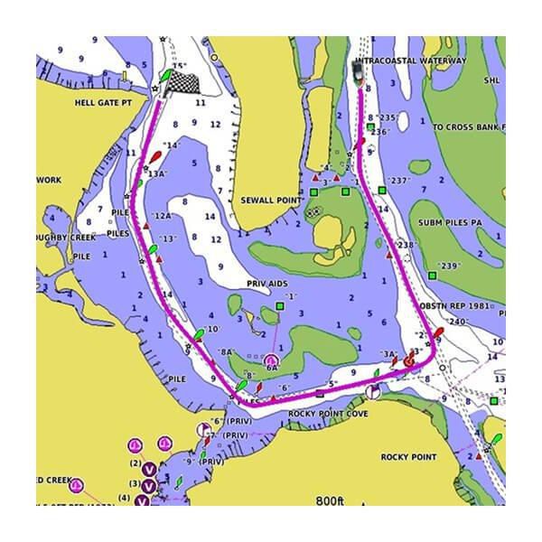
BlueChart g3 coastal charts provide industry-leading coverage, clarity and detail with integrated Garmin and Navionics data. Also included is Auto Guidance1 technology, which uses your desired depth and overhead clearance to calculate routes and provide a suggested path to follow — overlaid onto your chart. NOAA raster cartography is also available as a free downloadable feature via the ActiveCaptain app. It gives your chartplotter paper chartlike views of NOAA-surveyed areas in which individual...
Perskaitykite pilną aprašymąProvides industry-leading coverage, clarity and detail with updated coastal charts that feature integrated Garmin and Navionics® data
Auto Guidance¹ technology calculates a route using your desired depth and overhead clearance and provides a suggested path to follow
Includes Depth Range Shading for up to 10 depth ranges, enabling you to view your target depth at a glance
Up to 1’ contours provide a more accurate depiction of the bottom structure for improved fishing charts and navigation in swamps, canals and marinas
NOAA raster cartography is available as a free downloadable feature via the ActiveCaptain® app
Specifikacijos 010-C1209-20
Features
Brand compatibility
Garmin
Country coverage
Sweden
Region location
Europe
Type
Road map
Package dimensions
Gross Weight (Package, kg)
0,005 kg
Product dimensions
Net Weight (Product, kg)
0,004 kg
Product Depth
0,2 cm
Product Height
3,2 cm
Product Width
2,4 cm
Vendor information
Brand Name
Warranty
2 Metai
Aprašymas
Sweden Inland Waters
BlueChart g3 coastal charts provide industry-leading coverage, clarity and detail with integrated Garmin and Navionics data. Also included is Auto Guidance1 technology, which uses your desired depth and overhead clearance to calculate routes and provide a suggested path to follow — overlaid onto your chart. NOAA raster cartography is also available as a free downloadable feature via the ActiveCaptain app. It gives your chartplotter paper chartlike views of NOAA-surveyed areas in which individual points of interest are labeled with corresponding longitude and latitude information. Worldwide coverage is available by regions as accessory cards or via download; each region is sold separately.
Auto Guidance Technology
The Auto Guidance feature¹ calculates a suggested route using your desired depth and overhead clearance.
Depth Range Shading
This feature displays high-resolution Depth Range Shading for up to 10 depth ranges so you can view your designated target depth.
Detailed Contours
BlueChart g3 charts feature 1’ contours that provide a more accurate depiction of bottom structure for improved fishing charts and enhanced detail in swamps, canals and port plans.
Shallow Water Shading
To aid in navigation, Shallow Water Shading allows map shading at a user-defined depth to give a clear picture of shallow waters to avoid.
NOAA Raster Cartography
This feature gives your chartplotter paper chartlike views of NOAA-surveyed areas in which points of interest are labeled with corresponding longitude and latitude information.
*Aukščiau pateiktus gaminio duomenis pateikia „Icecat“. EET negali būti atsakinga už klaidas, susijusias su tuo.