- Accueil
- Electronique grand public
- Accessoires automobile
- Navigation
- Cartes GPS
- Garmin VUS021R - California-Mexico, microSD/SD – 010-C0722-00
Garmin VUS021R - California-Mexico, microSD/SD


Garmin VUS021R - California-Mexico, microSD/SD
MPN 010-C0722-00
EAN / UPC 753759069025
Niveau de stock
See your vessel’s precise, on-chart position in relation to navaids, coastal features and restricted areas with premium features found in this detailed marine mapping data. Includes all of the features of our BlueChart® g2 product, plus 3-D perspective above and below the waterline, Auto Guidance, high-resolution imagery, and aerial photos of ports, harbors, marinas and landmarks.
- Shaded depth contours, coastlines, spot soundings, navaids, port plans, wrecks, obstructions, intertidal zo...
Caractéristiques 010-C0722-00
Caractéristiques
Compatibilité de marque
Garmin
Détails de couverture
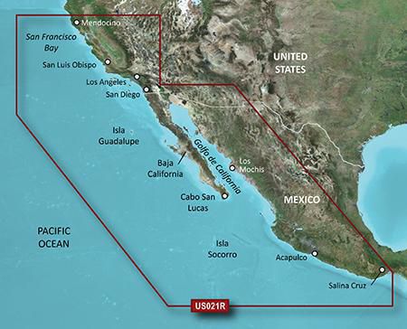
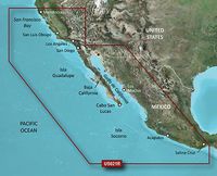
California - Mexico
Emplacement de la région
Amérique du nord
Nombre d'utilisateurs
1 utilisateur(s)
Type
Water map
Type de distribution
MicroSD/SD
Configuration minimale du système
Connexion Internet
Oui
Espace de disque dur minimum
1,4 Go
Mémoire vive (RAM) minimale
1024 Mo
Minimum de résolution d'affichage
1024 x 768 Pixels
USB requise
Oui
Package dimensions
Gross Weight (Package, kg)
5 kg
Product dimensions
Depth (product,cm)
2,39 cm
Height (product,cm)
18,72 cm
Net Weight (Product, kg)
4,9 kg
Product Width
14,4 cm
Vendor information
Brand Name
Warranty
2 Année (s)
Description
VUS021R - California-Mexico, microSD/SD
See your vessel’s precise, on-chart position in relation to navaids, coastal features and restricted areas with premium features found in this detailed marine mapping data. Includes all of the features of our BlueChart® g2 product, plus 3-D perspective above and below the waterline, Auto Guidance, high-resolution imagery, and aerial photos of ports, harbors, marinas and landmarks.
- Shaded depth contours, coastlines, spot soundings, navaids, port plans, wrecks, obstructions, intertidal zones, restricted areas and IALA symbols.
- Seamless transitions between zoom levels and more continuity across chart boundaries.
- High resolution satellite imagery for a realistic view of the land and water.
- Aerial photos of ports, harbors, marinas, waterways, navigational landmarks and other POIs.
- Auto Guidance technology searches chart data to suggest the best passage to a destination.
- MarinerEye view 3-D perspective for a quick, easy position fix.
- FishEye view 3-D perspective for an underwater view of the sea floor.
- Safety Shading* enables contour shading for all depth contours shallower than your defined safe depths.
- Fishing Charts* to scope out bottom contours and depth soundings with less visual clutter on the display.
- Plan and organize routes from your computer with HomePort™.
Coverage
Point Arena, CA to Puerto Vallarta, MX including Mendocino, San Francisco Bay, Channel Islands, San Diego, CA and the Baja Peninsula. General coverage for the Mexican coast including Cabo San Lucas, Mazatlan, Acapulco and Salina Cruz.
*Les données produit ci-dessus sont fournies par Icecat. A cet égard, EET ne peut être tenu responsable des erreurs.