- Accueil
- Electronique grand public
- Accessoires automobile
- Navigation
- Cartes GPS
- Garmin France Inland Waters, SD card – 010-C1104-20
Garmin France Inland Waters, SD card


Garmin France Inland Waters, SD card
MPN 010-C1104-20
EAN / UPC 753759107642
Niveau de stock
Unparalleled coastal chart coverage
BlueChart g3 coastal charts provide industry-leading coverage, clarity and detail with integrated Garmin and Navionics data. Also included is Auto Guidance technology, which uses your desired depth and overhead clearance to calculate routes and provide a suggested path to follow — overlaid onto your chart. NOAA raster cartography is also available as a free downloadable feature via the ActiveCaptain app. It gives your chartplotter paper chartlike views ...
Provides industry-leading coverage, clarity and detail with updated coastal charts that feature integrated Garmin and Navionics® data
Auto Guidance technology calculates a route using your desired depth and overhead clearance and provides a suggested path to follow
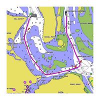
Includes Depth Range Shading for up to 10 depth ranges, enabling you to view your target depth at a glance
Up to 1-foot contours provide a more accurate depiction of the bottom structure for improved fishing charts and navigation in swamps, canals and marinas
Caractéristiques 010-C1104-20
Caractéristiques
Compatibilité de marque
Garmin
Contours de profondeur ombrés
Oui
Détails de couverture
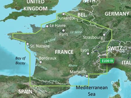
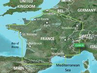
France Inland Waters
Emplacement de la région
Europe
Technologie d'auto-guidage
Oui
Type
Water map
Type de carte
Carte des eaux fraîches
Type de distribution
MicroSD/SD
Type de données de carte
Trame
Package dimensions
Gross Weight (Package, kg)
0,1 kg
Product dimensions
Net Weight (Product, kg)
0,09 kg
Vendor information
Brand Name
Warranty
2 Année (s)
Description
France Inland Waters, SD card
Unparalleled coastal chart coverage
BlueChart g3 coastal charts provide industry-leading coverage, clarity and detail with integrated Garmin and Navionics data. Also included is Auto Guidance technology, which uses your desired depth and overhead clearance to calculate routes and provide a suggested path to follow — overlaid onto your chart. NOAA raster cartography is also available as a free downloadable feature via the ActiveCaptain app. It gives your chartplotter paper chartlike views of NOAA-surveyed areas in which individual points of interest are labelled with corresponding longitude and latitude information. Worldwide coverage is available by regions as accessory cards or via download; each region is sold separately.
Auto Guidance technology
The Auto Guidance feature calculates a suggested route using your desired depth and overhead clearance.
Depth Range Shading
This feature displays high-resolution Depth Range Shading for up to 10 depth ranges, so you can view your designated target depth.
Detailed Contours
BlueChart g3 charts feature 1-foot contours that provide a more accurate depiction of bottom structure for improved fishing charts and enhanced detail in swamps, canals and port plans.
Shallow Water Shading
To aid in navigation, Shallow Water Shading allows map shading at a user-defined depth to give a clear picture of shallow waters to avoid.
*Les données produit ci-dessus sont fournies par Icecat. A cet égard, EET ne peut être tenu responsable des erreurs.