- Accueil
- Electronique grand public
- Accessoires automobile
- Navigation
- Cartes GPS
- Garmin HAE005R - Philippines-Java-Mariana Islands, microSD/SD – 010-C0880-20
Garmin HAE005R - Philippines-Java-Mariana Islands, microSD/SD

Garmin HAE005R - Philippines-Java-Mariana Islands, microSD/SD
MPN 010-C0880-20
EAN / UPC 753759090081
Niveau de stock
See your vessel’s precise, on-chart position in relation to navaids, coastal features, anchorages, obstructions, waterways, restricted areas and more with this detailed marine mapping data.
- Shaded depth contours, coastlines, spot soundings, navaids, port plans, wrecks, obstructions, intertidal zones, restricted areas and IALA symbols.
- Seamless transitions between zoom levels and more continuity across chart boundaries.
- Standard 2-D direct overhead or 3-D “over the bow” map per...
Caractéristiques 010-C0880-20
Caractéristiques
Compatibilité de marque
Garmin
Détails de couverture
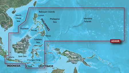
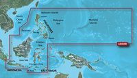
Philippines - Java-Mariana Islands
Emplacement de la région
Asie
Nombre d'utilisateurs
1 utilisateur(s)
Type
Water map
Type de distribution
MicroSD/SD
Configuration minimale du système
Connexion Internet
Oui
Espace de disque dur minimum
0,957 Go
Mémoire vive (RAM) minimale
1024 Mo
Minimum de résolution d'affichage
1024 x 768 Pixels
USB requise
Oui
Package dimensions
Gross Weight (Package, kg)
35 kg
Product dimensions
Depth (product,cm)
12,3 cm
Height (product,cm)
2 cm
Net Weight (Product, kg)
34,9 kg
Product Width
13 cm
Vendor information
Brand Name
Warranty
2 Année (s)
Description
HAE005R - Philippines-Java-Mariana Islands, microSD/SD
See your vessel’s precise, on-chart position in relation to navaids, coastal features, anchorages, obstructions, waterways, restricted areas and more with this detailed marine mapping data.
- Shaded depth contours, coastlines, spot soundings, navaids, port plans, wrecks, obstructions, intertidal zones, restricted areas and IALA symbols.
- Seamless transitions between zoom levels and more continuity across chart boundaries.
- Standard 2-D direct overhead or 3-D “over the bow” map perspective for easy chart reading and orientation.
- Safety Shading* enables contour shading for all depth contours shallower than your defined safe depths.
- Fishing Charts* to scope out bottom contours and depth soundings with less visual clutter on the display.
- Plan and organize routes from your computer with HomePort™.
Coverage
General coverage of the coasts of the Philippines, portions of Indonesia, including Java, and Malaysia located to the east of Singapore and west of Halmahera Island, and portions of East Timor. Included in this overall general coverage are numerous detailed charts covering areas such as the Indonesian cities of Jakarta, Semarang, and Ujungpandang, Manila, Phil., Kota Kinabalu, Mal., and Bandar Seri Begawan, Brun. General coverage of the Mariana Islands is also included.
*Les données produit ci-dessus sont fournies par Icecat. A cet égard, EET ne peut être tenu responsable des erreurs.