- Inicio
- Electrónica de Consumo
- Automotor
- Navegación
- Mapas para navegador
- Garmin VEU010R - Mediterranean Sea, Genova-Ayamonte, microSD/SD – 010-C0768-00
Garmin VEU010R - Mediterranean Sea, Genova-Ayamonte, microSD/SD


Garmin VEU010R - Mediterranean Sea, Genova-Ayamonte, microSD/SD
MPN 010-C0768-00
EAN / UPC 753759069483
Nivel de existencias
See your vessel’s precise, on-chart position in relation to navaids, coastal features and restricted areas with premium features found in this detailed marine mapping data. Includes all of the features of our BlueChart® g2 product, plus 3-D perspective above and below the waterline, Auto Guidance, high-resolution imagery, and aerial photos of ports, harbors, marinas and landmarks.
- Shaded depth contours, coastlines, spot soundings, navaids, port plans, wrecks, obstructions, intertidal zo...
Especificaciones de 010-C0768-00
Features
Compatibilidad de marca
Garmin
Detalles de cobertura
Mediterranean Sea, Genova - Ayamonte
Número de usuarios
1 usuario(s)
Tipo
Water map
Tipo de distribución
MicroSD/SD
Ubicación región
Europe
Package dimensions
Gross Weight (Package, kg)
105 kg
Product dimensions
Net Weight (Product, kg)
104,89999999999999 kg
Product Depth
2,39 cm
Product Height
18,72 cm
Product Width
14,4 cm
System requirements
Espacio mínimo en disco de almacenamiento
1,7 GB
RAM mínima
1024 MB
Requiere conexión a Internet
Yes
Requisito mínimo de resolución de pantalla
1024 x 768 Pixels
USB requerido
Yes
Vendor information
Brand Name
Warranty
2 Año/s
Descripción
VEU010R - Mediterranean Sea, Genova-Ayamonte, microSD/SD
See your vessel’s precise, on-chart position in relation to navaids, coastal features and restricted areas with premium features found in this detailed marine mapping data. Includes all of the features of our BlueChart® g2 product, plus 3-D perspective above and below the waterline, Auto Guidance, high-resolution imagery, and aerial photos of ports, harbors, marinas and landmarks.
- Shaded depth contours, coastlines, spot soundings, navaids, port plans, wrecks, obstructions, intertidal zones, restricted areas and IALA symbols.
- Seamless transitions between zoom levels and more continuity across chart boundaries.
- High resolution satellite imagery for a realistic view of the land and water.
- Aerial photos of ports, harbors, marinas, waterways, navigational landmarks and other POIs.
- Auto Guidance technology searches chart data to suggest the best passage to a destination.
- MarinerEye view 3-D perspective for a quick, easy position fix.
- FishEye view 3-D perspective for an underwater view of the sea floor.
- Safety Shading* enables contour shading for all depth contours shallower than your defined safe depths.
- Fishing Charts* to scope out bottom contours and depth soundings with less visual clutter on the display.
- Plan and organize routes from your computer with HomePort™.
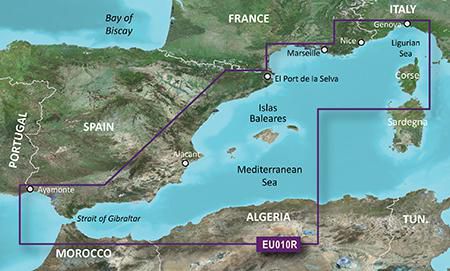
Coverage
Detailed coverage of the entire Spanish and French Mediterranean coast from the Straight of Gibraltar to La Spezia, IT. Includes coverage of Corse, the northern part of Sardegna, and the Islas Baleares. Also covers the northern coasts of Morocco and Algeria from Larache, MA, to Bejaia, DZ.
*Los datos de producto anteriores son proporcionados por Icecat. EET no se hace responsable de los errores en relación con esto.