- Startseite
- Unterhaltungselektronik
- Automobil
- Navigation
- Navigator-Karten
- Garmin HEU016R - Mediterranean Southeast, microSD/SD – 010-C0774-20
Garmin HEU016R - Mediterranean Southeast, microSD/SD

Garmin HEU016R - Mediterranean Southeast, microSD/SD
MPN 010-C0774-20
Artikel-Nr. W125647962
EAN / UPC 0753759091729
Lagerbestand
See your vessel’s precise, on-chart position in relation to navaids, coastal features, anchorages, obstructions, waterways, restricted areas and more with this detailed marine mapping data.
- Shaded depth contours, coastlines, spot soundings, navaids, port plans, wrecks, obstructions, intertidal zones, restricted areas and IALA symbols.
- Seamless transitions between zoom levels and more continuity across chart boundaries.
- Standard 2-D direct overhead or 3-D “over the bow” map per...
Spezifikationen für 010-C0774-20
Features
Abdeckungsdetails
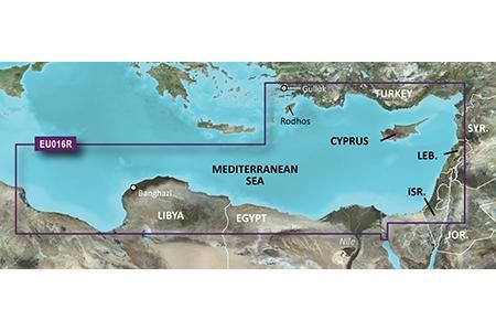
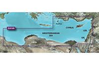
Mediterranean Southeast
Anzahl der Nutzer
1 Benutzer
Markenkompatibilität
Garmin
Typ
Water map
Verteilungstyp
MicroSD/SD
Package dimensions
Depth (package,cm)
13,018 cm
Gross Weight
0,02 kg
Height (package,cm)
0,953 cm
Width (package,cm)
12,065 cm
Product dimensions
Depth (product,cm)
0,2 cm
Height (product,cm)
3,2 cm
Net Weight
0,01 kg
Width (product,cm)
2,4 cm
System requirements
Internetverbindung erforderlich
Yes
Mindestanforderungen an die Bildschirmauflösung
1024 x 768 Pixels
Mindestspeicherplatz auf dem Laufwerk
0,1 GB
Minimum RAM
1024 MB
USB erforderlich
Yes
Vendor information
Brand Name
Warranty
2 Jahre)
Beschreibung
HEU016R - Mediterranean Southeast, microSD/SD
See your vessel’s precise, on-chart position in relation to navaids, coastal features, anchorages, obstructions, waterways, restricted areas and more with this detailed marine mapping data.
- Shaded depth contours, coastlines, spot soundings, navaids, port plans, wrecks, obstructions, intertidal zones, restricted areas and IALA symbols.
- Seamless transitions between zoom levels and more continuity across chart boundaries.
- Standard 2-D direct overhead or 3-D “over the bow” map perspective for easy chart reading and orientation.
- Safety Shading* enables contour shading for all depth contours shallower than your defined safe depths.
- Fishing Charts* to scope out bottom contours and depth soundings with less visual clutter on the display.
- Plan and organize routes from your computer with HomePort™.
Coverage
From Güllük, Turkey east to include Cyprus, Syria, Lebanon and Israel, then west to Misratah, Libya.
*Die oben genannten Produktdaten werden von Icecat zur Verfügung gestellt. EET ist nicht verantwortlich für eventuelle Fehler in diesem Zusammenhang.