- Startseite
- Unterhaltungselektronik
- Automobil
- Navigation
- Navigator-Karten
- Garmin HEU008R - Bay of Biscay, microSD/SD – 010-C0766-20
Garmin HEU008R - Bay of Biscay, microSD/SD


Garmin HEU008R - Bay of Biscay, microSD/SD
MPN 010-C0766-20
Artikel-Nr. W125647961
EAN / UPC 0753759091569
Lagerbestand
See your vessel’s precise, on-chart position in relation to navaids, coastal features, anchorages, obstructions, waterways, restricted areas and more with this detailed marine mapping data.
- Shaded depth contours, coastlines, spot soundings, navaids, port plans, wrecks, obstructions, intertidal zones, restricted areas and IALA symbols.
- Seamless transitions between zoom levels and more continuity across chart boundaries.
- Standard 2-D direct overhead or 3-D “over the bow” map...
Spezifikationen für 010-C0766-20
Features
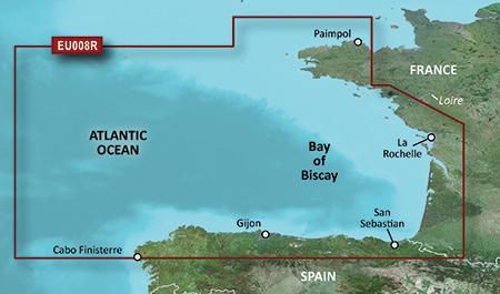
Geographische Abdeckung
Bay of Biscay
Typ
Road map
Package dimensions
Depth (package,cm)
13,018 cm
Gross Weight
0,02 kg
Height (package,cm)
0,953 cm
Width (package,cm)
12,065 cm
Product dimensions
Depth (product,cm)
0,2 cm
Height (product,cm)
3,2 cm
Net Weight
0,01 kg
Width (product,cm)
2,4 cm
Vendor information
Brand Name
Warranty
2 Jahre)
Beschreibung
HEU008R - Bay of Biscay, microSD/SD
See your vessel’s precise, on-chart position in relation to navaids, coastal features, anchorages, obstructions, waterways, restricted areas and more with this detailed marine mapping data.
- Shaded depth contours, coastlines, spot soundings, navaids, port plans, wrecks, obstructions, intertidal zones, restricted areas and IALA symbols.
- Seamless transitions between zoom levels and more continuity across chart boundaries.
- Standard 2-D direct overhead or 3-D “over the bow” map perspective for easy chart reading and orientation.
- Safety Shading* enables contour shading for all depth contours shallower than your defined safe depths.
- Fishing Charts* to scope out bottom contours and depth soundings with less visual clutter on the display.
- Plan and organize routes from your computer with HomePort™ (sold separately).
Coverage
From Binic, France to Cabo Finisterre, Spain.
*Die oben genannten Produktdaten werden von Icecat zur Verfügung gestellt. EET ist nicht verantwortlich für eventuelle Fehler in diesem Zusammenhang.