- Hjem
- Consumer Electronics
- Automotive
- Navigation
- Navigator Maps
- Garmin HAE009R - Sin/Mal/Indonesia, mciroSD/SD – 010-C0884-20
Garmin HAE009R - Sin/Mal/Indonesia, mciroSD/SD

Garmin HAE009R - Sin/Mal/Indonesia, mciroSD/SD
MPN 010-C0884-20
EAN/UPC 753759090166
Lager
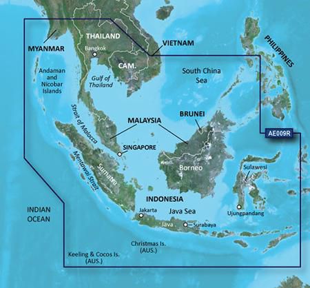
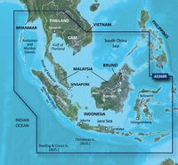
See your vessel’s precise, on-chart position in relation to navaids, coastal features, anchorages, obstructions, waterways, restricted areas and more with this detailed marine mapping data.
- Shaded depth contours, coastlines, spot soundings, navaids, port plans, wrecks, obstructions, intertidal zones, restricted areas and IALA symbols.
- Seamless transitions between zoom levels and more continuity across chart boundaries.
- Standard 2-D direct overhead or 3-D “over the bow” map per...
Specifikationer for 010-C0884-20
Features
Brand compatibility
Garmin
Coverage details
Sin, Mal, Indonesia
Distribution type
MicroSD/SD
Number of users
1 user(s)
Region location
Asia
Type
Water map
Package dimensions
Gross Weight (Package, kg)
35 kg
Product dimensions
Net Weight (Product, kg)
34,9 kg
Product Depth
12,3 cm
Product Height
2 cm
Product Width
13 cm
System requirements
Internet connection required
Yes
Minimum display resolution requirement
1024 x 768 Pixels
Minimum RAM
1024 MB
Minimum storage drive space
0,952 GB
USB required
Yes
Vendor information
Brand Name
Warranty
2 År
Beskrivelse
HAE009R - Sin/Mal/Indonesia, mciroSD/SD
See your vessel’s precise, on-chart position in relation to navaids, coastal features, anchorages, obstructions, waterways, restricted areas and more with this detailed marine mapping data.
- Shaded depth contours, coastlines, spot soundings, navaids, port plans, wrecks, obstructions, intertidal zones, restricted areas and IALA symbols.
- Seamless transitions between zoom levels and more continuity across chart boundaries.
- Standard 2-D direct overhead or 3-D “over the bow” map perspective for easy chart reading and orientation.
- Safety Shading* enables contour shading for all depth contours shallower than your defined safe depths.
- Fishing Charts* to scope out bottom contours and depth soundings with less visual clutter on the display.
- Plan and organize routes from your computer with HomePort™.
Coverage
Coverage of the entire Malay Peninsula; Thailand; Cambodia; southern Vietnam including Ho Chi Minh City and the Mekong Delta; Brunei and Indonesia west of Timor. Islands covered include Java, Sumatra, Sulawesi and Borneo, Indonesia; Christmas Islands, Keeling Islands, Cocos Islands and the Andaman and Nicobar Islands.
*Produktdata ovenfor leveres af Icecat. EET kan ikke holdes ansvarlig for fejl i forbindelse hertil.