- Hjem
- Consumer Electronics
- Automotive
- Navigation
- Navigator Maps
- Garmin VEU003R - Great Britain, Northeast Coast, microSD/SD – 010-C0762-00
Garmin VEU003R - Great Britain, Northeast Coast, microSD/SD


Garmin VEU003R - Great Britain, Northeast Coast, microSD/SD
MPN 010-C0762-00
EAN/UPC 753759091477
Lager
See your vessel’s precise, on-chart position in relation to navaids, coastal features and restricted areas with premium features found in this detailed marine mapping data. Includes all of the features of our BlueChart® g2 product, plus 3-D perspective above and below the waterline, Auto Guidance, high-resolution imagery, and aerial photos of ports, harbors, marinas and landmarks.
- Shaded depth contours, coastlines, spot soundings, navaids, port plans, wrecks, obstructions, intertidal zo...
Specifikationer for 010-C0762-00
Features
Compatibility
echoMAP™ 42dv echoMAP™ 45dv echoMAP™ 50dv echoMAP™ 50s echoMAP™ 52dv echoMAP™ 55dv echoMAP™ 70dv echoMAP™ 70s echoMAP™ 72sv echoMAP™ 75sv echoMAP™ 92sv echoMAP™ 95sv GPSMAP® 1020xs GPSMAP® 4008 GPSMAP® 4010 GPSMAP® 4012 GPSMAP® 420/420s GPSMAP® 450/450s GPSMAP® 451 GPSMAP® 451s GPSMAP® 5008 GPSMAP® 5012 GPSMAP® 5015 GPSMAP® 521 GPSMAP® 521s GPSMAP® 527 GPSMAP® 527xs GPSMAP® 550/550s GPSMAP® 551 GPSMAP® 551s GPSMAP® 555/555s GPSMAP® 556 GPSMAP® 556s GPSMAP® 557 GPSMAP® 557xs GPSMAP® 620 GPSMAP® 720 GPSMAP® 721 GPSMAP® 721xs GPSMAP® 7407 GPSMAP® 7407xsv GPSMAP® 7408 GPSMAP® 7408xsv GPSMAP® 7410 GPSMAP® 7410xsv GPSMAP® 7412 GPSMAP® 7412xsv GPSMAP® 7416 GPSMAP® 7416xsv GPSMAP® 750 GPSMAP® 750s GPSMAP® 751 GPSMAP® 751xs GPSMAP® 8008 MFD GPSMAP® 8012 MFD GPSMAP® 8015 MFD GPSMAP® 820 GPSMAP® 820xs GPSMAP® 8500 Black Box GPSMAP® 8530 Black Box Monterra™ Volvo Penta Glass Cockpit System
Geographic coverage
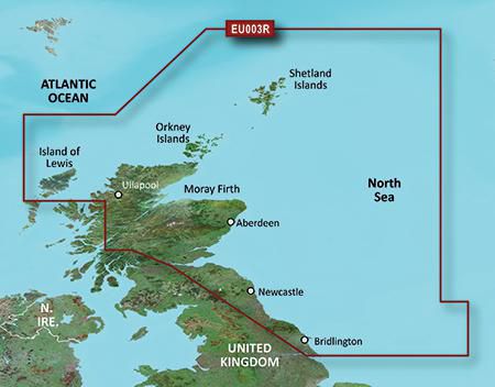
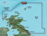
Great Britain, Northeast Coast
Type
Road map
Package dimensions
Depth (package,cm)
13,018 cm
Gross Weight (Package, kg)
0,3 kg
Height (package,cm)
0,953 cm
Width (package,cm)
12,065 cm
Product dimensions
Net Weight (Product, kg)
0,19999999999999998 kg
Product Depth
0,2 cm
Product Height
3,2 cm
Product Width
2,4 cm
Vendor information
Brand Name
Warranty
2 År
Beskrivelse
VEU003R - Great Britain, Northeast Coast, microSD/SD
See your vessel’s precise, on-chart position in relation to navaids, coastal features and restricted areas with premium features found in this detailed marine mapping data. Includes all of the features of our BlueChart® g2 product, plus 3-D perspective above and below the waterline, Auto Guidance, high-resolution imagery, and aerial photos of ports, harbors, marinas and landmarks.
- Shaded depth contours, coastlines, spot soundings, navaids, port plans, wrecks, obstructions, intertidal zones, restricted areas and IALA symbols.
- Seamless transitions between zoom levels and more continuity across chart boundaries.
- High resolution satellite imagery for a realistic view of the land and water.
- Aerial photos of ports, harbors, marinas, waterways, navigational landmarks and other POIs.
- Auto Guidance technology searches chart data to suggest the best passage to a destination.
- MarinerEye view 3-D perspective for a quick, easy position fix.
- FishEye view 3-D perspective for an underwater view of the sea floor.
- Safety Shading* enables contour shading for all depth contours shallower than your defined safe depths.
- Fishing Charts* to scope out bottom contours and depth soundings with less visual clutter on the display.
- Plan and organize routes from your computer with HomePort™ (sold separately).
Coverage
Covers from the Isle of Lewis, Scotland to Bridlington Harbour, England, including Gairloch, the Shetland Islands, Edinburgh, and North Sea offshore charts. Also includes the Caledonian Canal, Loch Linnhe, and Loch Ness.
*Produktdata ovenfor leveres af Icecat. EET kan ikke holdes ansvarlig for fejl i forbindelse hertil.