- Home
- Elektronika użytkowa
- Motoryzacja
- Nawigacja
- Nawigacja
- Garmin 3" 240 x 400 pix. TFT, 16 hours, IPX7, 4 GB, microSD, 6.1 x 11.4 x 3.3 cm, 209.8 g – 010-01066-30
Garmin 3" 240 x 400 pix. TFT, 16 hours, IPX7, 4 GB, microSD, 6.1 x 11.4 x 3.3 cm, 209.8 g


Garmin 3" 240 x 400 pix. TFT, 16 hours, IPX7, 4 GB, microSD, 6.1 x 11.4 x 3.3 cm, 209.8 g
MPN 010-01066-30
Poziom zapasów
More Features, More Satellite Power
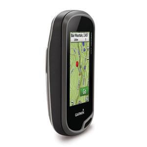
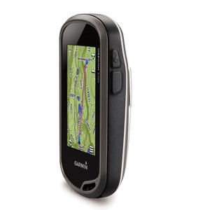
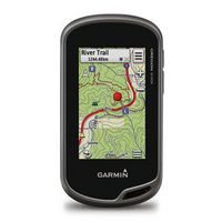
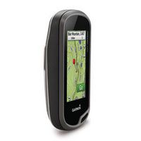
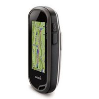
- 3-inch sunlight-readable touchscreen display with dual orientation
- Preloaded TOPO U.S. 100K maps with shaded relief basemap
- 8 megapixel autofocus, digital zoom camera with flash/torch
- 3-axis compass with accelerometer and barometric altimeter sensors
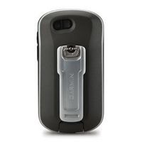
- Dual battery — 2 AA batteries or included rechargeable internal NiMH pack
With high-sensitivity GPS and GLONASS satellite tracking, preloaded TOPO U.S. 100K maps, worldwide basemap ...
Specyfikacje dla 010-01066-30
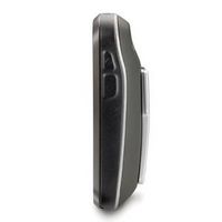
Design
Form factor
Handheld
International Protection (IP) code
IPX7
Product colour
Grey
Display
Backlight display
Yes
Display
TFT
Display diagonal
3 "
Display size (HxV) (imperial)
2.5 x 1.5 "
Touchscreen
Yes
GPS type
Auto
No
Aviation
No
Bicycle
No
Camper/Caravan
No
Geocaching (GPS stash hunt)
Yes
Golf
No
Marine (chartplotters, sounders)
No
Motorcycle
No
Outdoor (hiking, trekking)
Yes
Sport (fitness, running)
No
Truck
No
Map
Map coverage
All Europe
Maps included
Yes
Topographic map
Yes
Memory
Compatible memory cards
MicroSD (TransFlash)
Internal storage capacity
4 GB
Storage media type
Flash
Navigation
Area calculation
Yes
Automatic routing
Yes
Barometric altimeter
Yes
Electronic compass
Yes
Languages support
English
Live service
No
Live Traffic Message Channel (TMC)
No
Number of points of interest
10000
Number of waypoints
4000
Routes quantity
200
Tracks quantity
200
Traffic Message Channel (TMC)
No
Waypoints
Yes
Network
Bluetooth
No
Package dimensions
Gross Weight (Package, kg)
0,5 kg
Packaging content
AC adapter included
Yes
Batteries included
Yes
Cables included
USB
Manual
Yes
Performance
Built-in camera
Yes
Hunt/fish calendar
Yes
Image viewer
Yes
Megapixel (approx.)
8 MP
Sun & moon information
Yes
Text-to-speech message reader
No
Tide tables
Yes
Unit-to-unit transfer
Yes
Ports & interfaces
USB connectivity
Yes
Power
Battery life (max)
16 Hour
Battery technology
Nickel-Metal Hydride (NiMH)
Power source type
Battery
Product dimensions
Net Weight (Product, kg)
0,5 kg
Product Depth
3,3 cm
Product Height
11,4 cm
Product Width
6,1 cm
Vendor information
Brand Name
Warranty
1 Rok/Lata
Opis
3" 240 x 400 pix. TFT, 16 hours, IPX7, 4 GB, microSD, 6.1 x 11.4 x 3.3 cm, 209.8 g
More Features, More Satellite Power
- 3-inch sunlight-readable touchscreen display with dual orientation
- Preloaded TOPO U.S. 100K maps with shaded relief basemap
- 8 megapixel autofocus, digital zoom camera with flash/torch
- 3-axis compass with accelerometer and barometric altimeter sensors
- Dual battery — 2 AA batteries or included rechargeable internal NiMH pack
With high-sensitivity GPS and GLONASS satellite tracking, preloaded TOPO U.S. 100K maps, worldwide basemap with shaded relief, and customizable buttons for 1-touch image capture and waypoint marking, Oregon 650t opens a new world of GPS mapping and positioning.
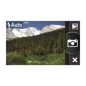
Quality Photos
Take quality photos with Oregon 650t's built-in 8 megapixel autofocus digital camera. Each photo is geotagged, allowing you to navigate back to that exact spot. Share the photos with all your friends through Garmin Adventures. For more storage, insert a microSD™ card. You can even view pictures from other devices on microSD card with Oregon’s picture viewer.
Touch and Go
Oregon 650t has reflective display technology for the most brilliant, sunlight readable touchscreen we’ve ever made. The screen is strengthened for impact resistance, with multi-touch and dual orientation views that accommodate gloved operation.
Double Your Power
Oregon 650t features our state-of-the-art dual battery system. You’ll have the option of using the internally rechargeable NiMH pack (included) or traditional AA batteries — NiMH pack charges when the device is connected to external power.
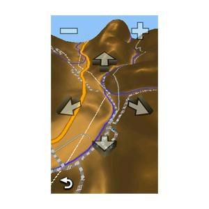
Explore the Terrain
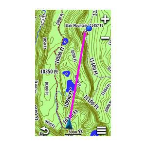
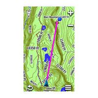
Oregon 650t comes with built-in US topographic data for the entire US, including Alaska, Hawaii and Puerto Rico, and a worldwide basemap with shaded relief — all the tools for serious climbing or hiking. Map detail includes national, state and local parks and forests, along with terrain contours, elevation information, trails, rivers, lakes and points of interest.
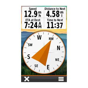
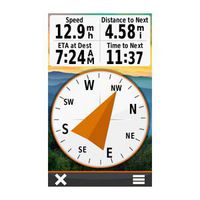
Oregon 650t has a built-in 3-axis electronic compass with accelerometer tilt compensation to show where you're heading even when standing still, or not holding it level. Its barometric altimeter tracks changes in pressure to pinpoint your precise altitude. You can even use it to plot barometric pressure over time to keep an eye on changing weather conditions.
With its high-sensitivity, WAAS- and GLONASS-enabled GPS receiver and HotFix® satellite prediction, Oregon 650t locates your position quickly and precisely, and maintains its GPS location even in heavy cover and deep canyons.
Share Wirelessly
With Oregon 650t you can share your waypoints, tracks, routes and geocaches up to 50 times faster with other wireless compatible Garmin handheld devices. Plus, you can share large files too like photos, Garmin Adventures and Custom Maps. Just touch “send” to transfer your information.
Add Maps
Adding more maps to Oregon is easy. Load TOPO U.S. 24K maps and hit the trail; add Trailhead Series TOPO maps and explore famous treks like the Appalachian Trail and the Pacific Crest Trail; plug in BlueChart® g2 preloaded cards for a great day on the water; or load City Navigator® map data for turn-by-turn routing on roads. Add satellite images to your maps with BirdsEye Satellite Imagery (subscription required).
Load All the Geocaches
No more picking, choosing and planning, just download them all. Oregon 650t can hold up to 4 million. Download every cache on Geocaching.com. Load caches using your favorite program or website that supports GGZ files. All your paperless geocaching features will be there for every cache. Read full descriptions, hints and logs. View cache photos. Filter caches by size, terrain, difficulty and type. Connect to chirp-enabled caches. Record your logs in the field. Do it all.
Plan Your Next Trip
Take charge of your next adventure with BaseCamp™, software that lets you view and organize maps, waypoints, routes and tracks. This free trip-planning software even allows you to create Garmin Adventures that you can share with friends, family or fellow explorers. BaseCamp displays topographic map data in 2-D or 3-D on your computer screen, including contour lines and elevation profiles. It also can transfer an unlimited amount of satellite images to your device when paired with a BirdsEye Satellite Imagery subscription.
*Powyższe dane produktu zostały dostarczone przez firmę Icecat. Firma EET nie ponosi odpowiedzialności za błędy w tym zakresie.