- Hjem
- Forbrukerelektronikk
- Bil
- Navigasjon
- Navigatorer
- Garmin zūmo XT 5.5-inch motorcycle navigator – 010-02296-10
Garmin zūmo XT 5.5-inch motorcycle navigator


 Play
Play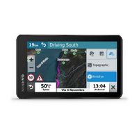
 Play
PlayGarmin zūmo XT 5.5-inch motorcycle navigator
MPN 010-02296-10
Varenr. W125648306
EAN/UPC 753759256340
Lagernivå
RIDE WITH TEAM ZŪMO
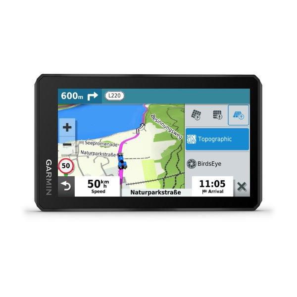
The rugged zūmo XT motorcycle navigator is built for adventure. Its ultrabright 5.5-inch display is glove-friendly, rain-resistant and shows you the adventurous way — on and off the beaten path.
ULTRABRIGHT DISPLAY
The 5.5-inch display is brighter than previous models and can be seen in any light. It’s also glove-friendly with crisp HD resolution in landscape or portrait mode.
RUGGED BUILD
Go confidently into every ride with a navig...
Spesifikasjoner for 010-02296-10
Design
Dustproof
Y/Yes
Easy to use
Y/Yes
Form factor
Handheld
Interface type
Touch Screen
LED indicators
Y/Yes
Product colour
Black
Temperature proof
Y/Yes
Water-resistant
Y/Yes
Display
Display
TFT
Display diagonal
5,5 "
Display resolution
1280 x 720 Pixels
Touchscreen
Y/Yes
Widescreen
Y/Yes
GPS Performance
Antenna
Internal
GPS type
Auto
Y/Yes
Bicycle
Y/Yes
Geocaching (GPS stash hunt)
Y/Yes
Marine (chartplotters, sounders)
Y/Yes
Motorcycle
Y/Yes
Outdoor (hiking, trekking)
Y/Yes
Sport (fitness, running)
Y/Yes
Truck
Y/Yes
Map
Lifetime map updates
N/No
Map storage
Internal storage
Memory
Compatible memory cards
MicroSD (TransFlash)
Internal storage capacity
32 GB
Storage media type
Memory card
Navigation
Address input
City/Geographical coordinates/Street
Quick search
Y/Yes
Road camera report
Y/Yes
Road signs
Y/Yes
Spoken street names
Y/Yes
Tap & Go
Y/Yes
Package dimensions
Depth (package,cm)
19,05 cm
Gross Weight (Package, kg)
1,173 kg
Height (package,cm)
14,605 cm
Width (package,cm)
11,684 cm
Performance
Alarm clock
Y/Yes
Built-in speaker(s)
Y/Yes
Calendar
Y/Yes
Clock mode
12h/24h
Integrated clock
Y/Yes
World travel clock
Y/Yes
Power
Battery life (max)
6 Hour
Battery technology
Lithium-Ion (Li-Ion)
Battery type
Built-in
Power source type
Battery
Product dimensions
Net Weight (Product, kg)
1,1 kg
Product Depth
2,4 cm
Product Height
8,8 cm
Product Width
14,8 cm
Vendor information
Brand Name
Warranty
2 År
Beskrivelse
zūmo XT 5.5-inch motorcycle navigator
RIDE WITH TEAM ZŪMO
The rugged zūmo XT motorcycle navigator is built for adventure. Its ultrabright 5.5-inch display is glove-friendly, rain-resistant and shows you the adventurous way — on and off the beaten path.
ULTRABRIGHT DISPLAY
The 5.5-inch display is brighter than previous models and can be seen in any light. It’s also glove-friendly with crisp HD resolution in landscape or portrait mode.
RUGGED BUILD
Go confidently into every ride with a navigator that’s built to withstand all kinds of weather (IPX7) and rough rides.
LASTING POWER
With the backlight set at 100% brightness, the battery lasts up to 3.5 hours, and it can go up to 6 hours on regular settings. Or you can hard-wire to constant power for longer adventures.
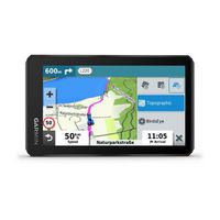
BIRDSEYE SATELLITE IMAGERY
You’ll have access to global BirdsEye Satellite Imagery with direct-to-device downloads via Wi-Fi® connectivity and no annual subscription.
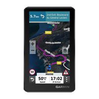
PRELOADED ON-ROAD MAPS
Be ready for the ride with preloaded street maps for all of Europe. Map updates included.
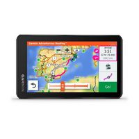
PRELOADED OFF-ROAD MAPS
Adventurous riding is encouraged with preloaded off-road topographic maps.
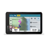
SIMPLE MAP SWITCHING
Quickly toggle between on-road maps, topographic maps and BirdsEye Satellite Imagery, so you can always have the perfect map for your ride.
GARMIN ADVENTUROUS ROUTING
Turn straightforward rides into twisting, gnarly adventures by selecting your road preferences.
TRACK RECORDER
Record your route by using the track recorder, and save or share it for future adventures.
SHARE YOUR FAVOURITE RIDES
Easily send GPX files from your phone to your zūmo XT, or share GPX files with fellow riders by using the Garmin Drive™ app.
Dokumenter
*Produktinformasjonen ovenfor er levert av Icecat. EET kan ikke holdes ansvarlig for feil i forbindelse med dette.