- Home
- Consumer Electronics
- Settore automobilistico
- Navigazione
- Mappe navigatore
- Garmin TOPO U.S. 100K, MicroSD – 010-C1098-00
Garmin TOPO U.S. 100K, MicroSD


Garmin TOPO U.S. 100K, MicroSD
MPN 010-C1098-00
EAN/UPC 753759998257
Livello stock
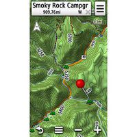
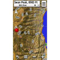
We've mapped every hill and valley for your next great adventure. Now with more detail than ever, this product covers the finer points of the outdoors with topographic maps comparable to 1:100,000 scale USGS maps. It also includes terrain contours, topo elevations, summits, parks, coastlines, rivers, lakes and geographical points.
- Provides detailed digital topographic maps, comparable to 1:100,000 scale USGS maps.
- Includes updated road content, by HERE (non-routable).
- Contains...
Specifiche per 010-C1098-00
Features
Brand compatibility
Garmin
Country coverage
USA
Distribution type
MicroSD/SD
Region location
North America
Type
Road map
Package dimensions
Gross Weight (Package, kg)
304 kg
Product dimensions
Net Weight (Product, kg)
303,9 kg
Vendor information
Brand Name
Warranty
2 Anno(i)
Descrizione
TOPO U.S. 100K, MicroSD
We've mapped every hill and valley for your next great adventure. Now with more detail than ever, this product covers the finer points of the outdoors with topographic maps comparable to 1:100,000 scale USGS maps. It also includes terrain contours, topo elevations, summits, parks, coastlines, rivers, lakes and geographical points.
- Provides detailed digital topographic maps, comparable to 1:100,000 scale USGS maps.
- Includes updated road content, by HERE (non-routable).
- Contains detailed hydrographic features, including coastlines, lake/river shorelines, wetlands and perennial and seasonal streams.
- Includes searchable points of interests, such as parks, campgrounds, scenic lookouts and picnic sites.
- Provides elevation profile on compatible devices so you can estimate terrain difficulty.
- Contains roads, trails and highways in metropolitan and rural areas, so getting to your destination is easy when you create point-to-point routes on compatible devices.
- Displays national, state and local parks, forests, and wilderness areas.
Includes digital topographic maps for the entire U.S., including Alaska, Hawaii and Puerto Rico.
*Le informazioni del prodotto sopra riportate sono fornite da Icecat. EET non può essere ritenuta responsabile di errori in relazione a ciò..