- Kezdőlap
- Fogyasztói elektronika
- Autóipari
- Navigáció
- Navigátor térképek
- Garmin HEU019R - Alborg-Amsterdam, microSD/SD – 010-C0776-20
Garmin HEU019R - Alborg-Amsterdam, microSD/SD

Garmin HEU019R - Alborg-Amsterdam, microSD/SD
MPN 010-C0776-20
EAN / UPC 753759091767
Készlet szint
See your vessel’s precise, on-chart position in relation to navaids, coastal features, anchorages, obstructions, waterways, restricted areas and more with this detailed marine mapping data.
- Shaded depth contours, coastlines, spot soundings, navaids, port plans, wrecks, obstructions, intertidal zones, restricted areas and IALA symbols.
- Seamless transitions between zoom levels and more continuity across chart boundaries.
- Standard 2-D direct overhead or 3-D “over the bow” map...
Specifikációk a termékről 010-C0776-20
Features
Geographic coverage
Alborg-Amsterdam
Language version
Unspecified
Type
Road map
Package dimensions
Gross Weight (Package, kg)
5 kg
Product dimensions
Net Weight (Product, kg)
4,9 kg
Vendor information
Brand Name
Warranty
2 Év(ek)
Leírás
HEU019R - Alborg-Amsterdam, microSD/SD
See your vessel’s precise, on-chart position in relation to navaids, coastal features, anchorages, obstructions, waterways, restricted areas and more with this detailed marine mapping data.
- Shaded depth contours, coastlines, spot soundings, navaids, port plans, wrecks, obstructions, intertidal zones, restricted areas and IALA symbols.
- Seamless transitions between zoom levels and more continuity across chart boundaries.
- Standard 2-D direct overhead or 3-D “over the bow” map perspective for easy chart reading and orientation.
- Safety Shading* enables contour shading for all depth contours shallower than your defined safe depths.
- Fishing Charts* to scope out bottom contours and depth soundings with less visual clutter on the display.
- Plan and organize routes from your computer with HomePort™.
Coverage
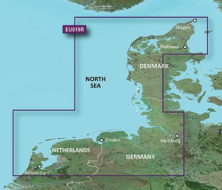
Includes detailed coverage from Ålborg Bugt to Amsterdam, The Netherlands, including Limfjorden, Hamburg, Bremen and Emden.
*A fenti termékadatokat az Icecat szolgáltatja. Az EET nem tehető felelőssé az ezzel kapcsolatos hibákért.