- Home
- Potrošačka elektronika
- Automobilski
- Navigacija
- Navigator Maps
- Garmin VEU506S - Crete-Cyprus, microSD/SD – 010-C0850-00
Garmin VEU506S - Crete-Cyprus, microSD/SD


Garmin VEU506S - Crete-Cyprus, microSD/SD
MPN 010-C0850-00
EAN/UPC 753759070304
Stanje zaliha
See your vessel’s precise, on-chart position in relation to navaids, coastal features and restricted areas with premium features found in this detailed marine mapping data. Includes all of the features of our BlueChart® g2 product, plus 3-D perspective above and below the waterline, Auto Guidance, high-resolution imagery, and aerial photos of ports, harbors, marinas and landmarks.
- Shaded depth contours, coastlines, spot soundings, navaids, port plans, wrecks, obstructions, intertidal zo...
Specifikacije za 010-C0850-00
Features
Geographic coverage
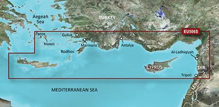
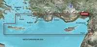
Crete-Cyprus
Language version
Unspecified
Type
Road map
Package dimensions
Gross Weight
5 kg
Product dimensions
Height (product,cm)
18,72 cm
Net Weight
4,9 kg
Product Depth
2,39 cm
Width (product,cm)
14,4 cm
Vendor information
Brand Name
Warranty
2 Godina
Opis
VEU506S - Crete-Cyprus, microSD/SD
See your vessel’s precise, on-chart position in relation to navaids, coastal features and restricted areas with premium features found in this detailed marine mapping data. Includes all of the features of our BlueChart® g2 product, plus 3-D perspective above and below the waterline, Auto Guidance, high-resolution imagery, and aerial photos of ports, harbors, marinas and landmarks.
- Shaded depth contours, coastlines, spot soundings, navaids, port plans, wrecks, obstructions, intertidal zones, restricted areas and IALA symbols.
- Seamless transitions between zoom levels and more continuity across chart boundaries.
- High resolution satellite imagery for a realistic view of the land and water.
- Aerial photos of ports, harbors, marinas, waterways, navigational landmarks and other POIs.
- Auto Guidance technology searches chart data to suggest the best passage to a destination.
- MarinerEye view 3-D perspective for a quick, easy position fix.
- FishEye view 3-D perspective for an underwater view of the sea floor.
- Safety Shading* enables contour shading for all depth contours shallower than your defined safe depths.
- Fishing Charts* to scope out bottom contours and depth soundings with less visual clutter on the display.
- Plan and organize routes from your computer with HomePort™.
Coverage
Detailed coverage of the southeastern Aegean Sea and Mediterranean Turkish coast. Crete and Cyprus are covered as well as the Aegean islands of Paros, Naxos, Thira, Kos, Rhodes and many others. Coastal coverage from Güllük, TR. to Tripoli, LB. including port plans of Antalya and Marmaris, TR. and Al-Ladhiqiyah (Latakia), SY.
*Gore navedene podatke o proizvodu pruža Icecat. EET se ne može smatrati odgovornim za pogreške u vezi s tim.