- Koti
- Kuluttajaelektroniikka
- Automotive
- Navigointi
- Navigaattori kartat
- Garmin HAE006R - Timor Leste/New Guinea, microSD/SD – 010-C0881-20
Garmin HAE006R - Timor Leste/New Guinea, microSD/SD

Garmin HAE006R - Timor Leste/New Guinea, microSD/SD
MPN 010-C0881-20
EAN/UPC 753759090104
Saatavuus
See your vessel’s precise, on-chart position in relation to navaids, coastal features, anchorages, obstructions, waterways, restricted areas and more with this detailed marine mapping data.
- Shaded depth contours, coastlines, spot soundings, navaids, port plans, wrecks, obstructions, intertidal zones, restricted areas and IALA symbols.
- Seamless transitions between zoom levels and more continuity across chart boundaries.
- Standard 2-D direct overhead or 3-D “over the bow” map per...
Tekniset tiedot 010-C0881-20
Features
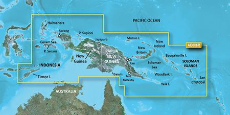
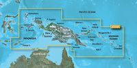
Geographic coverage
Timor Leste/New Guinea
Type
Road map
Package dimensions
Gross Weight (Package, kg)
0,01 kg
Product dimensions
Net Weight (Product, kg)
0,009 kg
Vendor information
Brand Name
Warranty
2 Vuosi(a)
Kuvaus
HAE006R - Timor Leste/New Guinea, microSD/SD
See your vessel’s precise, on-chart position in relation to navaids, coastal features, anchorages, obstructions, waterways, restricted areas and more with this detailed marine mapping data.
- Shaded depth contours, coastlines, spot soundings, navaids, port plans, wrecks, obstructions, intertidal zones, restricted areas and IALA symbols.
- Seamless transitions between zoom levels and more continuity across chart boundaries.
- Standard 2-D direct overhead or 3-D “over the bow” map perspective for easy chart reading and orientation.
- Safety Shading* enables contour shading for all depth contours shallower than your defined safe depths.
- Fishing Charts* to scope out bottom contours and depth soundings with less visual clutter on the display.
- Plan and organize routes from your computer with HomePort™ (sold separately).
Coverage
General coverage includes coasts of Timor Leste; the northernmost parts of Melville Island and the Cobourg Peninsula of Australia; Indonesia southeast and east of Sulawesi; Osprey Reef; all of Papua New Guinea and the Solomon Islands. Detailed coverage of Ambon, Indonesia; Snake Bay, Australia; Ternate, Indon, Lae, Rabaul, Karema and Port Moresby, P.N.G. and Honaira, S.I.
*Icecat toimittaa yllä olevat tuotetiedot. EET ei ole vastuussa niihin liittyvistä virheistä.