- Koti
- Kuluttajaelektroniikka
- Automotive
- Navigointi
- Navigaattori kartat
- Garmin VAE002R - Yellow Sea, microSD/SD – 010-C0877-00
Garmin VAE002R - Yellow Sea, microSD/SD


Garmin VAE002R - Yellow Sea, microSD/SD
MPN 010-C0877-00
EAN/UPC 753759070571
Saatavuus
See your vessel’s precise, on-chart position in relation to navaids, coastal features and restricted areas with premium features found in this detailed marine mapping data. Includes all of the features of our BlueChart® g2 product, plus 3-D perspective above and below the waterline, Auto Guidance, high-resolution imagery, and aerial photos of ports, harbors, marinas and landmarks.
- Shaded depth contours, coastlines, spot soundings, navaids, port plans, wrecks, obstructions, intertidal zo...
Tekniset tiedot 010-C0877-00
Features
Brand compatibility
Garmin
Coverage details
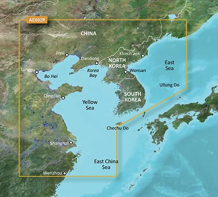
Yellow Sea
Distribution type
MicroSD/SD
Number of users
1 käyttäjä (t)
Region location
Asia
Type
Water map
Package dimensions
Gross Weight (Package, kg)
0,12 kg
Product dimensions
Depth (product,cm)
12,3 cm
Height (product,cm)
2 cm
Net Weight (Product, kg)
0,11 kg
Product Width
13 cm
System requirements
Internet connection required
Yes
Minimum display resolution requirement
1024 x 768 Pixels
Minimum RAM
1024 MB
Minimum storage drive space
2 GB
USB required
Yes
Vendor information
Brand Name
Warranty
2 Vuosi(a)
Kuvaus
VAE002R - Yellow Sea, microSD/SD
See your vessel’s precise, on-chart position in relation to navaids, coastal features and restricted areas with premium features found in this detailed marine mapping data. Includes all of the features of our BlueChart® g2 product, plus 3-D perspective above and below the waterline, Auto Guidance, high-resolution imagery, and aerial photos of ports, harbors, marinas and landmarks.
- Shaded depth contours, coastlines, spot soundings, navaids, port plans, wrecks, obstructions, intertidal zones, restricted areas and IALA symbols.
- Seamless transitions between zoom levels and more continuity across chart boundaries.
- High resolution satellite imagery for a realistic view of the land and water.
- Aerial photos of ports, harbors, marinas, waterways, navigational landmarks and other POIs.
- Auto Guidance technology searches chart data to suggest the best passage to a destination.
- MarinerEye view 3-D perspective for a quick, easy position fix.
- FishEye view 3-D perspective for an underwater view of the sea floor.
- Safety Shading* enables contour shading for all depth contours shallower than your defined safe depths.
- Fishing Charts* to scope out bottom contours and depth soundings with less visual clutter on the display.
- Plan and organize routes from your computer with HomePort™.
Coverage
General coverage of the Chinese coast from Wenzhou to Dandong; the South Korean coast in its entirety; the full west coast of North Korea and the east coast south of Kimch'aek. Included in this overall general coverage are numerous detailed charts covering areas in China such as Shanghai, Qingdao, and Dalian; and also Nampo, N.Kor., and Pusan, S. Kor.
*Icecat toimittaa yllä olevat tuotetiedot. EET ei ole vastuussa niihin liittyvistä virheistä.