- Inicio
- Electrónica de Consumo
- Automotor
- Navegación
- Mapas para navegador
- Garmin HEU002R - S/E England-Belux Inland Waters, microSD/SD – 010-C0761-20
Garmin HEU002R - S/E England-Belux Inland Waters, microSD/SD

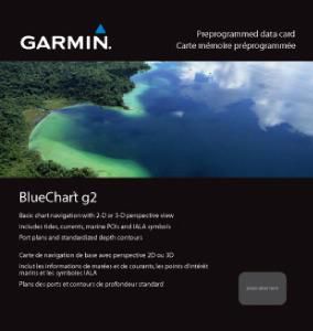

Garmin HEU002R - S/E England-Belux Inland Waters, microSD/SD
MPN 010-C0761-20
EAN / UPC 753759091460
Nivel de existencias
See your vessel’s precise, on-chart position in relation to navaids, coastal features, anchorages, obstructions, waterways, restricted areas and more with this detailed marine mapping data.
- Shaded depth contours, coastlines, spot soundings, navaids, port plans, wrecks, obstructions, intertidal zones, restricted areas and IALA symbols.
- Seamless transitions between zoom levels and more continuity across chart boundaries.
- Standard 2-D direct overhead or 3-D “over the bow” map per...
Especificaciones de 010-C0761-20
Features
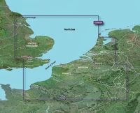
Cobertura geográfica
S/E England - Belux Inland Waters
Tipo
Road map
Package dimensions
Gross Weight (Package, kg)
5 kg
Product dimensions
Net Weight (Product, kg)
4,9 kg
Vendor information
Brand Name
Warranty
2 Año/s
Descripción
HEU002R - S/E England-Belux Inland Waters, microSD/SD
See your vessel’s precise, on-chart position in relation to navaids, coastal features, anchorages, obstructions, waterways, restricted areas and more with this detailed marine mapping data.
- Shaded depth contours, coastlines, spot soundings, navaids, port plans, wrecks, obstructions, intertidal zones, restricted areas and IALA symbols.
- Seamless transitions between zoom levels and more continuity across chart boundaries.
- Standard 2-D direct overhead or 3-D “over the bow” map perspective for easy chart reading and orientation.
- Safety Shading* enables contour shading for all depth contours shallower than your defined safe depths.
- Fishing Charts* to scope out bottom contours and depth soundings with less visual clutter on the display.
- Plan and organize routes from your computer with HomePort™.
Coverage
Detailed coverage of the south-east UK shores, part of the North Atlantic coast in Europe and also including some of the most popular Belgium and Luxembourg inland waterways, joining the French and Dutch river and canal network. Coverage includes the eastern UK coast from Scarborough to Shoreham including the River Thames up to Teddington, the northern European coast from Le Havre, FR to Amsterdam, NL and numerous interior rivers and canals including the Seine, the Somme, the Meuse, the Oise and the waterways network for Belgium and Luxembourg. Ports include Goole, London, Ramsgate, and Dover in the UK, Rotterdam, NL and Antwerp, BE and many others.
*Los datos de producto anteriores son proporcionados por Icecat. EET no se hace responsable de los errores en relación con esto.