- Home
- Consumer Electronics
- Automotive
- Navigation
- Navigator Maps
- Garmin VEU502S - Azores Islands, microSD/SD – 010-C0846-00
Garmin VEU502S - Azores Islands, microSD/SD


Garmin VEU502S - Azores Islands, microSD/SD
MPN 010-C0846-00
EAN/UPC 753759070267
Stock level
See your vessel’s precise, on-chart position in relation to navaids, coastal features and restricted areas with premium features found in this detailed marine mapping data. Includes all of the features of our BlueChart® g2 product, plus 3-D perspective above and below the waterline, Auto Guidance, high-resolution imagery, and aerial photos of ports, harbors, marinas and landmarks.
- Shaded depth contours, coastlines, spot soundings, navaids, port plans, wrecks, obstructions, intertidal zo...
Specifications for 010-C0846-00
Features
Geographic coverage
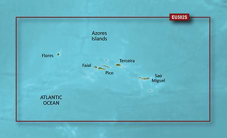
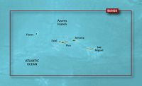
Azores Islands
Language version
Unspecified
Type
Road map
Package dimensions
Gross Weight (Package, kg)
5 kg
Product dimensions
Net Weight (Product, kg)
4.9 kg
Product Depth
2.39 cm
Product Height
18.72 cm
Product Width
14.4 cm
Vendor information
Brand Name
Warranty
2 Year(s)
Description
VEU502S - Azores Islands, microSD/SD
See your vessel’s precise, on-chart position in relation to navaids, coastal features and restricted areas with premium features found in this detailed marine mapping data. Includes all of the features of our BlueChart® g2 product, plus 3-D perspective above and below the waterline, Auto Guidance, high-resolution imagery, and aerial photos of ports, harbors, marinas and landmarks.
- Shaded depth contours, coastlines, spot soundings, navaids, port plans, wrecks, obstructions, intertidal zones, restricted areas and IALA symbols.
- Seamless transitions between zoom levels and more continuity across chart boundaries.
- High resolution satellite imagery for a realistic view of the land and water.
- Aerial photos of ports, harbors, marinas, waterways, navigational landmarks and other POIs.
- Auto Guidance technology searches chart data to suggest the best passage to a destination.
- MarinerEye view 3-D perspective for a quick, easy position fix.
- FishEye view 3-D perspective for an underwater view of the sea floor.
- Safety Shading* enables contour shading for all depth contours shallower than your defined safe depths.
- Fishing Charts* to scope out bottom contours and depth soundings with less visual clutter on the display.
- Plan and organize routes from your computer with HomePort™.
Coverage
Complete coverage of the Azores Islands with detailed port plans including Vila Da Praia, Santa Cruz, Horta, and S. Lourenço.
*The product data above is provided by Icecat. EET cannot be held responsible for errors in relation to this.