- Startseite
- Unterhaltungselektronik
- Automobil
- Navigation
- Navigator-Karten
- Garmin France Inland Waters, SD card – 010-C1104-00
Garmin France Inland Waters, SD card

Garmin France Inland Waters, SD card
MPN 010-C1104-00
EAN / UPC 753759107659
Lagerbestand
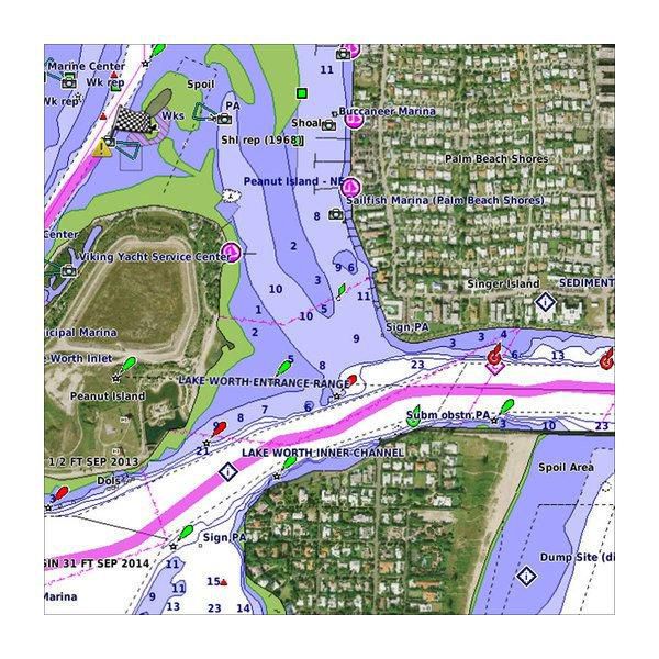
Premier coastal charts
Experience unparalleled coverage and brilliant detail when you’re on the water. BlueChart g3 Vision coastal charts provide industry-leading coverage, clarity and detail with integrated Garmin and Navionics content.
Auto Guidance
Whether you are fishing or cruising, select a spot, and get a route showing you the general path and nearby obstructions at a safe depth.
Depth Range Shading
This feature displays high-resolution Dep...
Industry-leading coverage, clarity and detail with updated coastal charts that feature integrated Garmin and Navionics® content
Auto Guidance technology quickly calculates a suggested route by using your desired depth and overhead clearance
Includes Depth Range Shading for up to 10 depth ranges, enabling you to view your target depth at a glance
Up to 1-foot contours provide a more accurate depiction of the bottom structure for improved fishing charts
To give a clear picture of shallow waters to avoid, the Shallow Water Shading allows for shading at a user-defined depth
Spezifikationen für 010-C1104-00
Features
3D über und unter der Wasserlinie
Yes
Abdeckungsdetails
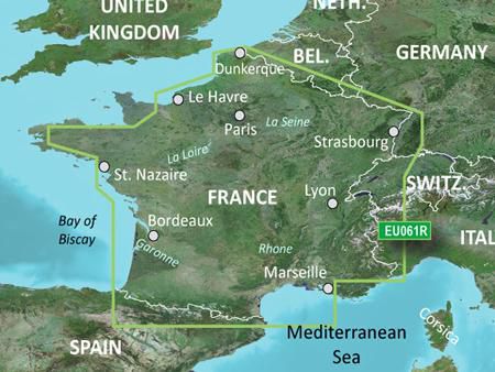
France Inland Waters
Auto Guidance-Technologie
Yes
Kartentyp
Freshwater map
Markenkompatibilität
Garmin
Satellitenbilder
Yes
Schattierte Tiefenkonturen
Yes
Standort der Region
Europe
Typ
Water map
Verteilungstyp
MicroSD/SD
Package dimensions
Gross Weight
0,1 kg
Product dimensions
Net Weight
0,09 kg
Vendor information
Brand Name
Warranty
2 Jahre)
Beschreibung
France Inland Waters, SD card
Premier coastal charts
Experience unparalleled coverage and brilliant detail when you’re on the water. BlueChart g3 Vision coastal charts provide industry-leading coverage, clarity and detail with integrated Garmin and Navionics content.
Auto Guidance
Whether you are fishing or cruising, select a spot, and get a route showing you the general path and nearby obstructions at a safe depth.
Depth Range Shading
This feature displays high-resolution Depth Range Shading for up to 10 depth ranges, so you can view your designated target depth.
Shallow Water Shading
To give a clear picture of shallow waters to avoid, this feature allows for shading at a user-defined depth.
Detailed contours
BlueChart g3 Vision charts feature 1-foot contours that provide a more accurate depiction of bottom structure for improved fishing charts and enhanced detail in swamps, canals and port plans.
Satellite imagery
Satellite imagery with navigational charts overlaid gives you a realistic view of your surroundings. It’s our most realistic charting display in a chartplotter — ideal for entering unfamiliar harbours or ports.
FishEye view
This underwater perspective shows 3-D representation of bottom and contours as seen from below the waterline. Interface with sonar data for a customised view.
MarinerEye view
This view provides a 3-D representation of the surrounding area both above and below the waterline.
Aerial photography
Crystal-clear aerial photography shows exceptional detail of many ports, harbours and marinas and is ideal when entering unfamiliar ports.
*Die oben genannten Produktdaten werden von Icecat zur Verfügung gestellt. EET ist nicht verantwortlich für eventuelle Fehler in diesem Zusammenhang.