- Startseite
- Unterhaltungselektronik
- Automobil
- Navigation
- Navigator-Karten
- Garmin HXCA015R - Canada g2, microSD/SD – 010-C1019-20
Garmin HXCA015R - Canada g2, microSD/SD

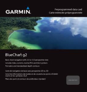

Garmin HXCA015R - Canada g2, microSD/SD
MPN 010-C1019-20
EAN / UPC 753759095758
Lagerbestand
See your vessel’s precise, on-chart position in relation to navaids, coastal features, anchorages, obstructions, waterways, restricted areas and more with this detailed marine mapping data.
- Shaded depth contours, coastlines, spot soundings, navaids, port plans, wrecks, obstructions, intertidal zones, restricted areas and IALA symbols.
- Seamless transitions between zoom levels and more continuity across chart boundaries.
- Standard 2-D direct overhead or 3-D “over the bow” map per...
Spezifikationen für 010-C1019-20
Features
Geographische Abdeckung
Canada g2
Typ
Road map
Package dimensions
Gross Weight (Package, kg)
5 kg
Product dimensions
Net Weight (Product, kg)
4,9 kg
Vendor information
Brand Name
Warranty
2 Jahre)
Beschreibung
HXCA015R - Canada g2, microSD/SD
See your vessel’s precise, on-chart position in relation to navaids, coastal features, anchorages, obstructions, waterways, restricted areas and more with this detailed marine mapping data.
- Shaded depth contours, coastlines, spot soundings, navaids, port plans, wrecks, obstructions, intertidal zones, restricted areas and IALA symbols.
- Seamless transitions between zoom levels and more continuity across chart boundaries.
- Standard 2-D direct overhead or 3-D “over the bow” map perspective for easy chart reading and orientation.
- Safety Shading* enables contour shading for all depth contours shallower than your defined safe depths.
- Fishing Charts* to scope out bottom contours and depth soundings with less visual clutter on the display.
- Plan and organize routes from your computer with HomePort™ (sold separately).
Coverage
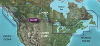
Provides detailed coverage of the east coast of North America from Nain, NL to Raritan Bay, NY featuring Newfoundland, Île d'Anticosti, New York Harbor and full U.S. and Canadian coverage of the Great Lakes in their entirety. The west coast of North America is covered from Glacier Bay, AK to Aberdeen, WA featuring British Columbia, Vancouver, the Queen Charlotte Islands and Puget Sound.
*Die oben genannten Produktdaten werden von Icecat zur Verfügung gestellt. EET ist nicht verantwortlich für eventuelle Fehler in diesem Zusammenhang.