- Startseite
- Unterhaltungselektronik
- Automobil
- Navigation
- Navigator-Karten
- Garmin HAF003R - Western Africa, microSD/SD – 010-C0749-20
Garmin HAF003R - Western Africa, microSD/SD


Garmin HAF003R - Western Africa, microSD/SD
MPN 010-C0749-20
EAN / UPC 753759089689
Lagerbestand
See your vessel’s precise, on-chart position in relation to navaids, coastal features, anchorages, obstructions, waterways, restricted areas and more with this detailed marine mapping data.
- Shaded depth contours, coastlines, spot soundings, navaids, port plans, wrecks, obstructions, intertidal zones, restricted areas and IALA symbols.
- Seamless transitions between zoom levels and more continuity across chart boundaries.
- Standard 2-D direct overhead or 3-D “over the bow” map...
Spezifikationen für 010-C0749-20
Features
Abdeckungsdetails
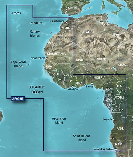
Western Africa
Anzahl der Nutzer
1 Benutzer
Markenkompatibilität
Garmin
Standort der Region
West Africa
Typ
Water map
Verteilungstyp
MicroSD/SD
Package dimensions
Gross Weight
36 kg
Product dimensions
Depth (product,cm)
12.3 cm
Height (product,cm)
2 cm
Net Weight
35.9 kg
Width (product,cm)
13 cm
System requirements
Internetverbindung erforderlich
Yes
Mindestanforderungen an die Bildschirmauflösung
1024 x 768 Pixels
Mindestspeicherplatz auf dem Laufwerk
0.313 GB
Minimum RAM
1024 MB
USB erforderlich
Yes
Vendor information
Brand Name
Warranty
2 Jahre)
Beschreibung
HAF003R - Western Africa, microSD/SD
See your vessel’s precise, on-chart position in relation to navaids, coastal features, anchorages, obstructions, waterways, restricted areas and more with this detailed marine mapping data.
- Shaded depth contours, coastlines, spot soundings, navaids, port plans, wrecks, obstructions, intertidal zones, restricted areas and IALA symbols.
- Seamless transitions between zoom levels and more continuity across chart boundaries.
- Standard 2-D direct overhead or 3-D “over the bow” map perspective for easy chart reading and orientation.
- Safety Shading* enables contour shading for all depth contours shallower than your defined safe depths.
- Fishing Charts* to scope out bottom contours and depth soundings with less visual clutter on the display.
- Plan and organize routes from your computer with HomePort™.
Coverage
General coverage of the west coast of Africa from El Aaraich, Mor. to Cape Cross, Nam., including Abidjan, C.I., Douala, Cam. and Luanda, Ang. Included in this overall general coverage are a number of detailed charts covering areas such as Casablanca, Mor., Dakar, Sen., and Lagos, Nig. Also includes general coverage of St. Helena Is., Ascension Is., and the Azores. Also includes detailed coverage of the Madeira Islands, Canary Islands, and Cape Verde Islands.
*Die oben genannten Produktdaten werden von Icecat zur Verfügung gestellt. EET ist nicht verantwortlich für eventuelle Fehler in diesem Zusammenhang.