- Startseite
- Unterhaltungselektronik
- Automobil
- Navigation
- Navigator-Karten
- Garmin VEU453S - Adriatic Sea, South Coast, microSD/SD – 010-C0797-00
Garmin VEU453S - Adriatic Sea, South Coast, microSD/SD


Garmin VEU453S - Adriatic Sea, South Coast, microSD/SD
MPN 010-C0797-00
EAN / UPC 753759069773
Lagerbestand
See your vessel’s precise, on-chart position in relation to navaids, coastal features and restricted areas with premium features found in this detailed marine mapping data. Includes all of the features of our BlueChart® g2 product, plus 3-D perspective above and below the waterline, Auto Guidance, high-resolution imagery, and aerial photos of ports, harbors, marinas and landmarks.
- Shaded depth contours, coastlines, spot soundings, navaids, port plans, wrecks, obstructions, intertidal zo...
Spezifikationen für 010-C0797-00
Features
Geographische Abdeckung
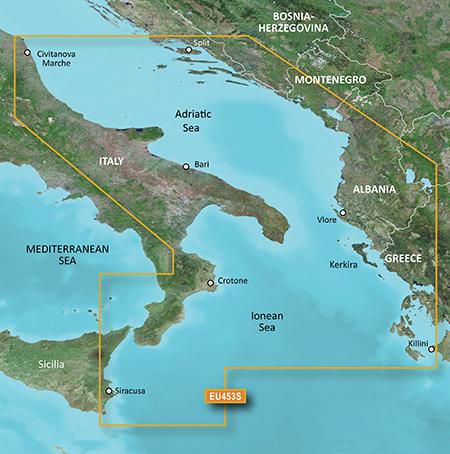
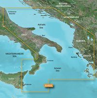
Adriatic Sea, South Coast
Kompatibilität
echoMAP™ 42dv echoMAP™ 50dv echoMAP™ 50s echoMAP™ 52dv echoMAP™ 70dv echoMAP™ 70s echoMAP™ 72sv echoMAP™ 91sv echoMAP™ 92sv GPSMAP 527 GPSMAP 721 GPSMAP® 1020xs GPSMAP® 4008 GPSMAP® 4010 GPSMAP® 4012 GPSMAP® 421/421s GPSMAP® 421/421s GPSMAP® 5008 GPSMAP® 5012 GPSMAP® 5015 GPSMAP® 521/521s GPSMAP® 521/521s GPSMAP® 526/526s GPSMAP® 526/526s GPSMAP® 527xs GPSMAP® 6008 GPSMAP® 6012 GPSMAP® 620 GPSMAP® 7012 GPSMAP® 7015 GPSMAP® 720/720s GPSMAP® 720/720s GPSMAP® 721xs GPSMAP® 7407 GPSMAP® 7407xsv GPSMAP® 7408 GPSMAP® 7408xsv GPSMAP® 7410 GPSMAP® 7410xsv GPSMAP® 7412 GPSMAP® 7412xsv GPSMAP® 7416 GPSMAP® 7416xsv GPSMAP® 820 GPSMAP® 820xs Monterra™
Sprachversion
Unspecified
Typ
Road map
Package dimensions
Gross Weight
5 kg
Product dimensions
Height (product,cm)
18,72 cm
Net Weight
4,9 kg
Tiefe cm
2,39 cm
Width (product,cm)
14,4 cm
Vendor information
Brand Name
Warranty
2 Jahre)
Beschreibung
VEU453S - Adriatic Sea, South Coast, microSD/SD
See your vessel’s precise, on-chart position in relation to navaids, coastal features and restricted areas with premium features found in this detailed marine mapping data. Includes all of the features of our BlueChart® g2 product, plus 3-D perspective above and below the waterline, Auto Guidance, high-resolution imagery, and aerial photos of ports, harbors, marinas and landmarks.
- Shaded depth contours, coastlines, spot soundings, navaids, port plans, wrecks, obstructions, intertidal zones, restricted areas and IALA symbols.
- Seamless transitions between zoom levels and more continuity across chart boundaries.
- High resolution satellite imagery for a realistic view of the land and water.
- Aerial photos of ports, harbors, marinas, waterways, navigational landmarks and other POIs.
- Auto Guidance technology searches chart data to suggest the best passage to a destination.
- MarinerEye view 3-D perspective for a quick, easy position fix.
- FishEye view 3-D perspective for an underwater view of the sea floor.
- Safety Shading* enables contour shading for all depth contours shallower than your defined safe depths.
- Fishing Charts* to scope out bottom contours and depth soundings with less visual clutter on the display.
- Plan and organize routes from your computer with HomePort™ (sold separately).
Coverage
Italian coast: from Porto Civitanova to extend south to Siracusa, Sicilia. From Split, Croatia to Killini, Greece.
*Die oben genannten Produktdaten werden von Icecat zur Verfügung gestellt. EET ist nicht verantwortlich für eventuelle Fehler in diesem Zusammenhang.