- Startseite
- Unterhaltungselektronik
- Automobil
- Navigation
- Navigator-Karten
- Garmin BlueChart g3 HXSA002R, South America West Coast, SD card – 010-C1063-20
Garmin BlueChart g3 HXSA002R, South America West Coast, SD card


Garmin BlueChart g3 HXSA002R, South America West Coast, SD card
MPN 010-C1063-20
EAN / UPC 753759974336
Lagerbestand
Our Advanced Chart Offering
Advanced Chart Detail
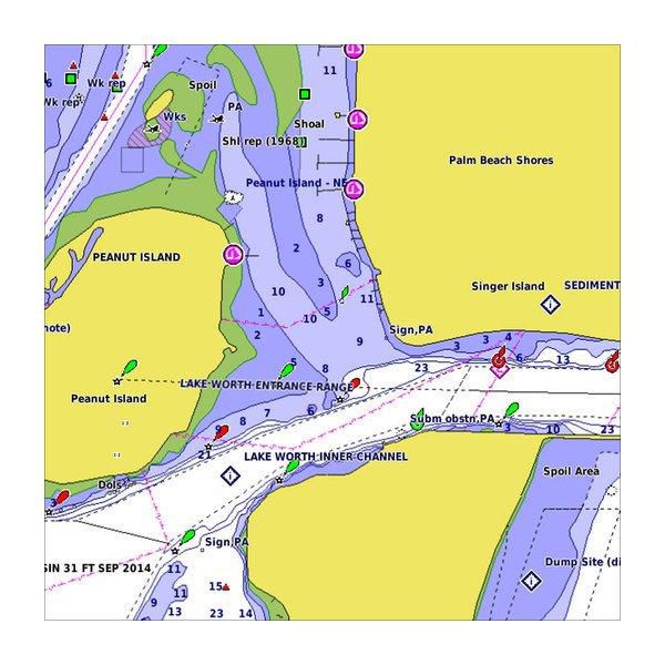
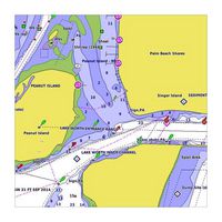
Detailed charts help the mariner guide their boat in and out of port with confidence.
Depth Range Shading
Displays high-resolution Depth Range Shading for up to 10 depth ranges so you can view your designated target depth.
Detailed Contours
BlueChart g2 HD features 1-foot contours that provide a more accurate depiction of bottom structure for improved fishing charts and enhanced detai...
Derived from official charts and private sources to provide navigational aids, spot soundings, depth contours, tides and currents, and detailed harbors and marinas
Depth Range Shading for up to 10 depth ranges enables you to view your target depth at a glance
Up to 1-foot contours provide a more accurate depiction of the bottom structure for improved fishing charts and navigation in swamps, canals and marinas
Shallow Water Shading feature allows for depth shading at a user-defined level to aid in navigation
Worldwide coverage available
Keep your charts up to date with our industry-leading New Chart Guarantee and discount card update program
Spezifikationen für 010-C1063-20
Features
Abdeckungsdetails
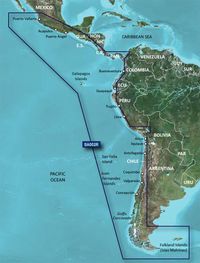
South America West Coast
Häfen plant
Yes
Kartendatentyp
Raster
Kartentyp
Nautical map
Markenkompatibilität
Garmin
Schattierte Tiefenkonturen
Yes
Standort der Region
South America
Typ
Water map
Verteilungstyp
MicroSD/SD
Package dimensions
Gross Weight (Package, kg)
5 kg
Product dimensions
Net Weight (Product, kg)
4,9 kg
Vendor information
Brand Name
Warranty
2 Jahre)
Beschreibung
BlueChart g3 HXSA002R, South America West Coast, SD card
Our Advanced Chart Offering
Advanced Chart Detail
Detailed charts help the mariner guide their boat in and out of port with confidence.
Depth Range Shading
Displays high-resolution Depth Range Shading for up to 10 depth ranges so you can view your designated target depth.
Detailed Contours
BlueChart g2 HD features 1-foot contours that provide a more accurate depiction of bottom structure for improved fishing charts and enhanced detail in swamps, canals and port plans.
Coverage of the west coast of Central and South America from Acalpulco, Mexico to Tierra del Fuego and then north to Puerto Deseado, Argentina. Coverage also includes the east coast of Panama; the Panama Canal; the Galapagos Islands; Lake Titicaca; the Falkland Islands (Islas Malvinas); San Felix Island and the San Fernandez Islands including Selkirk.
*Die oben genannten Produktdaten werden von Icecat zur Verfügung gestellt. EET ist nicht verantwortlich für eventuelle Fehler in diesem Zusammenhang.