- Startseite
- Unterhaltungselektronik
- Automobil
- Navigation
- Navigator-Karten
- Garmin HUS039R - US All & Canadian West Coast g2, microSD/SD – 010-C1018-20
Garmin HUS039R - US All & Canadian West Coast g2, microSD/SD


Garmin HUS039R - US All & Canadian West Coast g2, microSD/SD
MPN 010-C1018-20
EAN / UPC 753759095789
Lagerbestand
See your vessel’s precise, on-chart position in relation to navaids, coastal features, anchorages, obstructions, waterways, restricted areas and more with this detailed marine mapping data.
- Shaded depth contours, coastlines, spot soundings, navaids, port plans, wrecks, obstructions, intertidal zones, restricted areas and IALA symbols.
- Seamless transitions between zoom levels and more continuity across chart boundaries.
- Standard 2-D direct overhead or 3-D “over the bow” map per...
Spezifikationen für 010-C1018-20
Features
Abdeckungsdetails
West Coast
Anzahl der Nutzer
1 Benutzer
Art
Water map
Kartentyp
Freshwater & nautical map
Markenkompatibilität
Garmin
Standort der Region
North America
Verteilungstyp
MicroSD/SD
Package dimensions
Gross Weight (Package, kg)
0,22 kg
Product dimensions
Net Weight (Product, kg)
0,2 kg
System requirements
Internetverbindung erforderlich
Yes
Mindestanforderungen an die Bildschirmauflösung
1024 x 768 Pixels
Mindestspeicherplatz auf dem Laufwerk
2,9 GB
Minimum RAM
1024 MB
USB erforderlich
Yes
Vendor information
Brand Name
Warranty
2 Jahre)
Beschreibung
HUS039R - US All & Canadian West Coast g2, microSD/SD
See your vessel’s precise, on-chart position in relation to navaids, coastal features, anchorages, obstructions, waterways, restricted areas and more with this detailed marine mapping data.
- Shaded depth contours, coastlines, spot soundings, navaids, port plans, wrecks, obstructions, intertidal zones, restricted areas and IALA symbols.
- Seamless transitions between zoom levels and more continuity across chart boundaries.
- Standard 2-D direct overhead or 3-D “over the bow” map perspective for easy chart reading and orientation.
- Safety Shading* enables contour shading for all depth contours shallower than your defined safe depths.
- Fishing Charts* to scope out bottom contours and depth soundings with less visual clutter on the display.
- Plan and organize routes from your computer with HomePort™.
Coverage
Now featuring data from Explorer Charts for the Bahamas
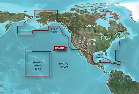
Provides detailed coverage of the eastern coast of the U.S. from Key West, FL to the Canadian border and the western coast from the Mexican border to Puget Sound, Alaska, Hawaii and major inland rivers, the U.S. Gulf Coast to the Mexican border and the Mexican Gulf Coast thru to the Yucatan. Canadian coverage includes the entire St. Lawrence Seaway, Nova Scotia and New Brunswick. The Great Lakes are covered in their entirety as are the Lake of the Woods. Coverage includes Prince Edward Island, Anticosti Island, Vancouver Island including the Inside and Outside Passages, Aleutian and Channel Islands, Bahamas, Turks and Caicos Islands, Cozumel, Cuba, Hispaniola, Puerto Rico and the U.S. Virgin Islands.
*Die oben genannten Produktdaten werden von Icecat zur Verfügung gestellt. EET ist nicht verantwortlich für eventuelle Fehler in diesem Zusammenhang.