- Hlavní stránka
- Spotřební elektronika
- Automotive
- Navigace
- Navigační mapy
- Garmin Oslo-Mandal-Smogen, SD card – 010-C1069-00
Garmin Oslo-Mandal-Smogen, SD card

Garmin Oslo-Mandal-Smogen, SD card
MPN 010-C1069-00
EAN / UPC 753759980757
Úroveň zásob
Premier coastal charts
Auto Guidance
Whether you are fishing or cruising, select a spot, and get a route showing you the general path and nearby obstructions at a safe depth.
Depth Range Shading
This feature displays high-resolution Depth Range Shading for up to 10 depth ranges, so you can view your designated target depth.
Shallow Water Shading
To give a clear picture of shallow waters to avoid, this feature allows for shading at a ...
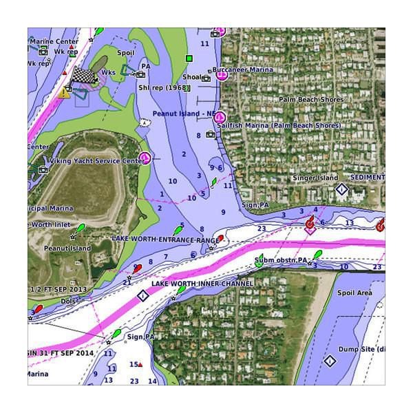
Industry-leading coverage, clarity and detail with updated coastal charts that feature integrated Garmin and Navionics® content
Auto Guidance technology quickly calculates a suggested route by using your desired depth and overhead clearance
Includes Depth Range Shading for up to 10 depth ranges, enabling you to view your target depth at a glance
Up to 1-foot contours provide a more accurate depiction of the bottom structure for improved fishing charts
To give a clear picture of shallow waters to avoid, the Shallow Water Shading allows for shading at a user-defined depth
Specifikace pro 010-C1069-00
Features
3D above & below waterline
Y/Yes
Aerial photos
Y/Yes
Brand compatibility
Garmin
Coverage details
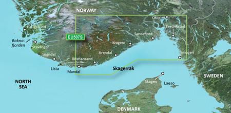
Oslo-Mandal-Smogen
Distribution type
MicroSD/SD
Map data type
Raster
Map type
Freshwater & nautical map
Ports plans
Y/Yes
Region location
Europe
Satellite imageries
Y/Yes
Shaded depth contours
Y/Yes
Type
Water map
Package dimensions
Gross Weight (Package, kg)
5 kg
Product dimensions
Net Weight (Product, kg)
4,9 kg
Vendor information
Brand Name
Warranty
2 Rok (y)
Popis
Oslo-Mandal-Smogen, SD card
Premier coastal charts
Auto Guidance
Whether you are fishing or cruising, select a spot, and get a route showing you the general path and nearby obstructions at a safe depth.
Depth Range Shading
This feature displays high-resolution Depth Range Shading for up to 10 depth ranges, so you can view your designated target depth.
Shallow Water Shading
To give a clear picture of shallow waters to avoid, this feature allows for shading at a user-defined depth.
Detailed contours
BlueChart g3 Vision charts feature 1-foot contours that provide a more accurate depiction of bottom structure for improved fishing charts and enhanced detail in swamps, canals and port plans.
Satellite imagery
Satellite imagery with navigational charts overlaid gives you a realistic view of your surroundings. It’s our most realistic charting display in a chartplotter — ideal for entering unfamiliar harbours or ports.
FishEye view
This underwater perspective shows 3-D representation of bottom and contours as seen from below the waterline. Interface with sonar data for a customised view.
MarinerEye view
This view provides a 3-D representation of the surrounding area both above and below the waterline.
Aerial photography
Crystal-clear aerial photography shows exceptional detail of many ports, harbours and marinas and is ideal when entering unfamiliar ports.
*Výše uvedené údaje o produktu poskytuje společnost Icecat. EET nenese odpovědnost za chyby v této souvislosti.