- Hlavní stránka
- Spotřební elektronika
- Automotive
- Navigace
- Navigační mapy
- Garmin HEU505S - Baltic Sea, East Coast, microSD/SD – 010-C0849-20
Garmin HEU505S - Baltic Sea, East Coast, microSD/SD


Garmin HEU505S - Baltic Sea, East Coast, microSD/SD
MPN 010-C0849-20
EAN / UPC 753759093044
Úroveň zásob
See your vessel’s precise, on-chart position in relation to navaids, coastal features, anchorages, obstructions, waterways, restricted areas and more with this detailed marine mapping data.
- Shaded depth contours, coastlines, spot soundings, navaids, port plans, wrecks, obstructions, intertidal zones, restricted areas and IALA symbols.
- Seamless transitions between zoom levels and more continuity across chart boundaries.
- Standard 2-D direct overhead or 3-D “over the bow” map per...
Specifikace pro 010-C0849-20
Features
Brand compatibility
Garmin
Coverage details
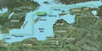
Baltic Sea, East Coast
Distribution type
MicroSD/SD
Number of users
1 uživatel/ů
Region location
Europe
Type
Water map
Package dimensions
Gross Weight (Package, kg)
5 kg
Product dimensions
Net Weight (Product, kg)
4,9 kg
System requirements
Internet connection required
Yes
Minimum display resolution requirement
1024 x 768 Pixels
Minimum RAM
1024 MB
Minimum storage drive space
0,088 GB
USB required
Yes
Vendor information
Brand Name
Warranty
2 Rok (y)
Popis
HEU505S - Baltic Sea, East Coast, microSD/SD
See your vessel’s precise, on-chart position in relation to navaids, coastal features, anchorages, obstructions, waterways, restricted areas and more with this detailed marine mapping data.
- Shaded depth contours, coastlines, spot soundings, navaids, port plans, wrecks, obstructions, intertidal zones, restricted areas and IALA symbols.
- Seamless transitions between zoom levels and more continuity across chart boundaries.
- Standard 2-D direct overhead or 3-D “over the bow” map perspective for easy chart reading and orientation.
- Safety Shading* enables contour shading for all depth contours shallower than your defined safe depths.
- Fishing Charts* to scope out bottom contours and depth soundings with less visual clutter on the display.
- Plan and organize routes from your computer with HomePort™.
Coverage
Coverage of the Baltic Sea coasts of Germany, Poland, Russia, Lithuania, Latvia and Estonia from Rügen, DE to Narva-Jõesuu, EE including the entire Gulf of Riga. Detailed coverage includes the Szczecin and Vistula Lagoons, the ports of Gydnia and Kaliningrad, the islands of Bornholm, Gotland, Saaremaa, Hiiumaa, Lake Peipus, the Emajõgi River and the Mazurian District Lakes including Lake Jeziorak, Lake Łańskie and Lake Śniardwy.
*Výše uvedené údaje o produktu poskytuje společnost Icecat. EET nenese odpovědnost za chyby v této souvislosti.