- Hlavní stránka
- Spotřební elektronika
- Automotive
- Navigace
- Navigační mapy
- Garmin VEU454S - Barcelona & Valencia, microSD/SD – 010-C0798-00
Garmin VEU454S - Barcelona & Valencia, microSD/SD


Garmin VEU454S - Barcelona & Valencia, microSD/SD
MPN 010-C0798-00
EAN / UPC 753759069780
Úroveň zásob
See your vessel’s precise, on-chart position in relation to navaids, coastal features and restricted areas with premium features found in this detailed marine mapping data. Includes all of the features of our BlueChart® g2 product, plus 3-D perspective above and below the waterline, Auto Guidance, high-resolution imagery, and aerial photos of ports, harbors, marinas and landmarks.
- Shaded depth contours, coastlines, spot soundings, navaids, port plans, wrecks, obstructions, intertidal zo...
Specifikace pro 010-C0798-00
Features
Geographic coverage
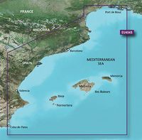
Barcelona & Valencia
Language version
Unspecified
Type
Road map
Package dimensions
Gross Weight (Package, kg)
105 kg
Product dimensions
Depth (product,cm)
2,39 cm
Height (product,cm)
18,72 cm
Net Weight (Product, kg)
104,89999999999999 kg
Product Width
14,4 cm
Vendor information
Brand Name
Warranty
2 Rok (y)
Popis
VEU454S - Barcelona & Valencia, microSD/SD
See your vessel’s precise, on-chart position in relation to navaids, coastal features and restricted areas with premium features found in this detailed marine mapping data. Includes all of the features of our BlueChart® g2 product, plus 3-D perspective above and below the waterline, Auto Guidance, high-resolution imagery, and aerial photos of ports, harbors, marinas and landmarks.
- Shaded depth contours, coastlines, spot soundings, navaids, port plans, wrecks, obstructions, intertidal zones, restricted areas and IALA symbols.
- Seamless transitions between zoom levels and more continuity across chart boundaries.
- High resolution satellite imagery for a realistic view of the land and water.
- Aerial photos of ports, harbors, marinas, waterways, navigational landmarks and other POIs.
- Auto Guidance technology searches chart data to suggest the best passage to a destination.
- MarinerEye view 3-D perspective for a quick, easy position fix.
- FishEye view 3-D perspective for an underwater view of the sea floor.
- Safety Shading* enables contour shading for all depth contours shallower than your defined safe depths.
- Fishing Charts* to scope out bottom contours and depth soundings with less visual clutter on the display.
- Plan and organize routes from your computer with HomePort™.
Coverage
From Port de Bouc, France to Cabo de Palos, Spain, including Islas Baleares.
*Výše uvedené údaje o produktu poskytuje společnost Icecat. EET nenese odpovědnost za chyby v této souvislosti.