- Hlavní stránka
- Spotřební elektronika
- Automotive
- Navigace
- Navigační mapy
- Garmin VAF003R - Western Africa, microSD/SD – 010-C0749-00
Garmin VAF003R - Western Africa, microSD/SD


Garmin VAF003R - Western Africa, microSD/SD
MPN 010-C0749-00
EAN / UPC 753759069292
Úroveň zásob
See your vessel’s precise, on-chart position in relation to navaids, coastal features and restricted areas with premium features found in this detailed marine mapping data. Includes all of the features of our BlueChart® g2 product, plus 3-D perspective above and below the waterline, Auto Guidance, high-resolution imagery, and aerial photos of ports, harbors, marinas and landmarks.
- Shaded depth contours, coastlines, spot soundings, navaids, port plans, wrecks, obstructions, intertidal zo...
Specifikace pro 010-C0749-00
Features
Compatibility
echoMAP™ 45dv echoMAP™ 50dv echoMAP™ 50s echoMAP™ 55dv echoMAP™ 70dv echoMAP™ 70s echoMAP™ 75dv echoMAP™ 75sv echoMAP™ 95sv GPSMAP® 1020xs GPSMAP® 1040xs GPSMAP® 4010 GPSMAP® 451 GPSMAP® 451s GPSMAP® 5008 GPSMAP® 551 GPSMAP® 551s GPSMAP® 556 GPSMAP® 556s GPSMAP® 557 GPSMAP® 557xs GPSMAP® 6008 GPSMAP® 6012 GPSMAP® 7012 GPSMAP® 7015 GPSMAP® 7407xsv GPSMAP® 7408xsv GPSMAP® 7410xsv GPSMAP® 7412xsv GPSMAP® 7416xsv GPSMAP® 750 GPSMAP® 751 GPSMAP® 751xs GPSMAP® 8008 MFD GPSMAP® 8012 MFD GPSMAP® 8015 MFD GPSMAP® 820xs GPSMAP® 8500 Black Box GPSMAP® 8530 Black Box Monterra™
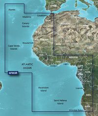
Geographic coverage
Western Africa
Type
Road map
Package dimensions
Gross Weight (Package, kg)
25 kg
Product dimensions
Height (product,cm)
2 cm
Net Weight (Product, kg)
24,9 kg
Product Depth
12,3 cm
Product Width
13 cm
Vendor information
Brand Name
Warranty
2 Rok (y)
Popis
VAF003R - Western Africa, microSD/SD
See your vessel’s precise, on-chart position in relation to navaids, coastal features and restricted areas with premium features found in this detailed marine mapping data. Includes all of the features of our BlueChart® g2 product, plus 3-D perspective above and below the waterline, Auto Guidance, high-resolution imagery, and aerial photos of ports, harbors, marinas and landmarks.
- Shaded depth contours, coastlines, spot soundings, navaids, port plans, wrecks, obstructions, intertidal zones, restricted areas and IALA symbols.
- Seamless transitions between zoom levels and more continuity across chart boundaries.
- High resolution satellite imagery for a realistic view of the land and water.
- Aerial photos of ports, harbors, marinas, waterways, navigational landmarks and other POIs.
- Auto Guidance technology searches chart data to suggest the best passage to a destination.
- MarinerEye view 3-D perspective for a quick, easy position fix.
- FishEye view 3-D perspective for an underwater view of the sea floor.
- Safety Shading* enables contour shading for all depth contours shallower than your defined safe depths.
- Fishing Charts* to scope out bottom contours and depth soundings with less visual clutter on the display.
- Plan and organize routes from your computer with HomePort™ (sold separately).
Coverage
General coverage of the west coast of Africa from El Aaraich, Mor. to Cape Cross, Nam., including Abidjan, C.I., Douala, Cam. and Luanda, Ang. Included in this overall general coverage are a number of detailed charts covering areas such as Casablanca, Mor., Dakar, Sen., and Lagos, Nig. Also includes general coverage of St. Helena Is., Ascension Is., and the Azores. Also includes detailed coverage of the Madeira Islands, Canary Islands, and Cape Verde Islands.
*Výše uvedené údaje o produktu poskytuje společnost Icecat. EET nenese odpovědnost za chyby v této souvislosti.