- Hlavní stránka
- Spotřební elektronika
- Automotive
- Navigace
- Navigační mapy
- Garmin HUS031R - Southwest Caribbean, microSD/SD – 010-C0732-20
Garmin HUS031R - Southwest Caribbean, microSD/SD

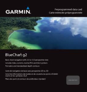

Garmin HUS031R - Southwest Caribbean, microSD/SD
MPN 010-C0732-20
EAN / UPC 753759089368
Úroveň zásob
See your vessel’s precise, on-chart position in relation to navaids, coastal features, anchorages, obstructions, waterways, restricted areas and more with this detailed marine mapping data.
- Shaded depth contours, coastlines, spot soundings, navaids, port plans, wrecks, obstructions, intertidal zones, restricted areas and IALA symbols.
- Seamless transitions between zoom levels and more continuity across chart boundaries.
- Standard 2-D direct overhead or 3-D “over the bow” map per...
Specifikace pro 010-C0732-20
Features
Brand compatibility
Garmin
Coverage details
Southwest Caribbean
Distribution type
MicroSD/SD
Number of users
1 uživatel/ů
Type
Water map
Package dimensions
Gross Weight (Package, kg)
0,05 kg
Product dimensions
Net Weight (Product, kg)
0,04 kg
System requirements
Internet connection required
Yes
Minimum display resolution requirement
1024 x 768 Pixels
Minimum RAM
1024 MB
Minimum storage drive space
0,228 GB
USB required
Yes
Vendor information
Brand Name
Warranty
2 Rok (y)
Popis
HUS031R - Southwest Caribbean, microSD/SD
See your vessel’s precise, on-chart position in relation to navaids, coastal features, anchorages, obstructions, waterways, restricted areas and more with this detailed marine mapping data.
- Shaded depth contours, coastlines, spot soundings, navaids, port plans, wrecks, obstructions, intertidal zones, restricted areas and IALA symbols.
- Seamless transitions between zoom levels and more continuity across chart boundaries.
- Standard 2-D direct overhead or 3-D “over the bow” map perspective for easy chart reading and orientation.
- Safety Shading* enables contour shading for all depth contours shallower than your defined safe depths.
- Fishing Charts* to scope out bottom contours and depth soundings with less visual clutter on the display.
- Plan and organize routes from your computer with HomePort™.
Coverage
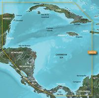
Detailed coverage of the northern coast of Central America from Cancun, Mexico to Barranquilla, Colombia including the Panama Canal in its entirety. General coverage of the northern half of the Gulf of Panama. Also includes detailed coverage of the coasts of Cuba, Jamaica, and the Caymans in their entirety.
*Výše uvedené údaje o produktu poskytuje společnost Icecat. EET nenese odpovědnost za chyby v této souvislosti.